Postcard with 1911 postmark from Indian Point, Maine.
September 28, 2021: Partly sunny, high 60s, very little wind.
The Community School is an independent elementary and middle school housed in a rambling old farmhouse near the mouth of Babson Creek in Somesville (aka Kittredge Brook – more about Babson and Kittredge here and here.) The Alpine class (6th-8th grade) was studying property rights and public access, so they invited me to talk about my experiences around that with this project. I suggested we turn it into a field trip – because why stay indoors when you could mess around on the shore? – and follow up the discussion with making still life photos on the shore.
So we met at the school, scrambled down the road embankment, and settled ourselves on some comfortable rocks. I talked about the process of requesting permission from landowners, and the different laws regulating access to the shoreline, and how they descended from laws put in place in 1641 when Maine was part of Massachusetts (according to the British) and still in the process of being colonized. (Good summary of those laws here.) They had already done some reading about the colonial laws and asked a lot of questions about where and how public access is protected, and about the legal status of the intertidal zone.
They also wanted to know what questions people ask me most often about the project, which are:
‘Why don’t you just go ahead and walk the shore?’ followed by
‘Isn’t the intertidal public land?’ and
‘What do you do in the winter?’ [That last one made them laugh, because it’s a question every islander gets asked during tourist season.]
The answers are: ‘Because I’m kind of a nerd and breaking rules makes me very uncomfortable, but also because a lot of local institutions are enthusiastic about the Coast Walk and help me contact landowners, so if I were to be arrested for trespassing it would reflect poorly on them’;
‘Sometimes, and it depends a lot on what you are doing in the intertidal’; and
‘The same things that I do in the summer, but with warmer clothing.’ [Which also made them laugh because it’s so obvious.]
Then we took a snack break, and did some beachcombing. I talked a little bit about my thought process when making a still life, and then got out of their way and watched them run with it.
After we took iPhone pictures of everyone’s work, we went back up to the school, where I plugged in my portable photo printer, and made 4×6 prints of their photos.
I suspect this was everyone’s favorite part of the whole field trip. The printer lays down each color separately – first yellow, then red, then blue, then black – and it’s pretty cool to watch the image change with each layer.
Photo of Harbor Cottage, and business card of A.C.Savage, Proprietor. Photo courtesy of Rick Savage.
Several people I interviewed had told me Rick Savage would be a good person to talk to about the Asticou area and the Savage family, so on November 6, 2017, Rick and I met to talk history. Rick is a seventh-generation member of the Savage family, a charter boat captain, and a marine surveyor. He’s had a few other careers as well, but I’ll let him tell you about that himself!
Rick: How can I help you?
Jenn: Well, I’m interested both in the history of
the MDI shoreline and also in how people are working on the shoreline now. So
I’m doubly interested in talking with you, because of your family history, and because
you’re a boat builder and a charter captain.
Rick: I’ve been a boat charter captain for 45
years. I haven’t built any boats since about 2003. I’m also a marine surveyor. A
surveyor inspects boats for insurance companies, and financial institutions,
and people who are buying boats and things like that. I’ve been doing that for
15 years.
Jenn: That sounds kind of complicated.
Rick: You’re required to get educational credits every year, and you have to belong to a professional organization. I’m pleased to belong to the group – there are only about 20 of us in Maine that are certified to do it. There are other people who do it on their own.
Jenn: So you come in when someone’s buying a boat,
or when there’s been storm damage or something?
Rick: I could. Particularly it’s for insurance
purposes. Or if somebody goes to the bank, wants to borrow money, and they put
the boat up for collateral, the bank would insist on an inspection and survey.
Very much like buying a house. … Anyway, getting back to the Savage family, I’m
seventh generation. I’m living on Savage property that was passed down to me
from my father, and his father, and his grandfather before him. So I feel very
fortunate to be here. Mount Desert Island is a wonderful place to live, if you
can find a way to make a living.
Jenn: Tell me about it!
Rick: I’ve always said that unless you’re in a profession that pays you well, you have to wear a variety of hats. I did the boat building in the winter, and the boat charter business in the summer. I’ve been doing that for a long time.
So, I don’t know where to start. I’ve done a lot of research about island history, particularly Northeast Harbor – mainly because of my family. I first became interested in the bicentennial year, 1976. At the time I had two older relatives, cousins, who were in their 70s and 80s, and they were very pleased that somebody of the younger generation was showing an interest. You can’t mandate that every generation likes genealogy or history. I don’t think [my father’s generation] really knew much about the family history. It was the previous generation that did. I was very fortunate to be the recipient of old papers and family bibles and photographs and letters, that actually meant a lot to me. So I’ve carried on from there.
Rick: And that was just a short span of time ago.
When Tim Garrity [ed.note: director of
the MDI Historical Society] asked me to write that, I said, “Nobody’d
be interested in that.” You know, my era, it wasn’t that long ago. And he
asked me how old I was, and I told him, and he said, “Yeah, you’re old
enough.” [Laughs] But it doesn’t
seem really possible.
Jenn: Well the funny thing is, the island has
changed so much in the last 30 years we do need to document what it used to be
like.
Rick: It’s since the mid ’80s, the dramatic
change that I’ve seen. I grew up here in this village, went to high school
here. I was really encouraged to get out and go away to get a job. I went away
to college. It was pretty grim around here in the ’60s. Bar Harbor had never
recovered from the fire. My parents were schoolteachers, and my father had
started a small heating oil business. Northeast Harbor was prosperous in the
summer, but there were a lot of people unemployed in the wintertime. So my
generation was encouraged to leave. Most of my classmates did, for a
spell. I came back a few years later and
wondered what I was going to do, but I’ve never regretted it. I think things
were starting to change by the time I came back here.
Jenn: I encouraged my kids to go away for college.
You appreciate the island more when you come back.
Rick: Well, both of my kids are back here now,
and I was really surprised. My son has got a successful tree business, and my
daughter and her husband are teachers, and they have a comfortable home. I
think they both realize it’s a nice place to live. So, what would you like to
know? Would you like to know something about the Savage family?
Jenn: I want to know everything. [We both laughed.] Are you working on any projects right now that you’re really interested in? Either history or boats.
Rick: Well, I am actually. I’m writing a story about growing up here. The article in Chebacco was taken from what I’m writing. I have done a number of talks to historical groups and things like that around the island.
Rick: I ought to show you this map first. This is a survey map by John Peters, he was a surveyor in Blue Hill, Maine, and he did the eastern half of Mount Desert Island. The island was divided in two originally. The Bernard Tract was the western side and the DeGregoire tract was the eastern side.
You know the original settlers came around 1761, the Someses and Richardsons, and my family came here in 1792. They got kicked out of town.
Jenn: What!?
Rick: Yeah, because they didn’t own property. They called you an indigent if you didn’t have land ownership, so my family didn’t come back until 1798. John Savage (the first) bought this tract of land by Harbor Brook and this is where they settled. The east side of Harbor Brook, which is that little stream right there. It’s just off Bear Island.
So the background for John Savage the first – he was born in 1756. Came to America at 14 years of age.
Jenn: Wow.
Rick: That’s because when you turned 14 in
Scotland, you were considered an adult, and you had to have a means of
employment. I’ve been to Glasgow and tried to look up my family genealogy. I
was told over there that either you had to be a land owner, or Catholic to have
any records. They weren’t either one, and I found no records.
Jenn: That’s too bad.
He had seven children, and three of the sons stayed in the area, and the daughters married into other families. But my direct ancestor, John Savage (the second), was born in 1801, three years after they came here. So there was John the first, John the second, then A.C. Savage, then A.C. had four sons, one of them was my grandfather, and then my father, and then me, and then my children. When he was 16, John Savage the second and a man named Will Roberts bought these two tracts of land, up here at the head of the harbor:
detail of Peters, “Plan of the French Grant on Mount Desert,” Northeast Harbor Library
The irony of it is, the direct ancestry always came down to one child, every time. John Savage the first had three sons. One was drowned, one eventually moved out of this area and went to Southwest Harbor. But John Savage the second settled here on the site of the Asticou Inn. This is the earliest depiction of the Asticou Inn area. [The house on the left] is John Savage the second’s farmhouse, it sits right where the hotel sits today. This is the same road location:
Painting of Asticou ca.1860-1870, by John L. Hughes, ca.1880. Image courtesy of the Northeast Harbor Library via Maine Memory Network.
Rick: John Savage II had seven children – only one son lived to maturity, and that was A.C. Savage. All the other sons died. One was killed in the Civil War before he was married, the other sons died of – they called it consumption, but that was TB – and other diseases. It was a tough time. All the daughters died young, without any families. A.C. Savage was the only survivor out of seven children.
A.C. Savage and his father were partners and they went coasting – shipping up and down the coast – that’s how they made their living. A.C. married Emily Manchester and built his home in 1854: the house that you see there in the painting is the second house, Cranberry Lodge [the house on the right.] This scene didn’t really change for 30 years, until the first Asticou Inn was built in 1883 on that site. A.C. Savage and Emily raised eight children. And my grandfather was John C. Savage, one of the last of the children.
Jenn: Where are we standing to get this view?
Rick: We’re standing out in the harbor, looking back. This is an original painting done by a family member. At the time, Mount Desert Island was pretty well populated, although Northeast Harbor and Seal Harbor were not. Bar Harbor, Somesville, and the Southwest Harbor side were populated. Seal Harbor and Northeast were the last areas to be settled on the island.
Jenn: Do you know why?
Rick: My theory is that Northeast Harbor wasn’t a
very good harbor.
Jenn: Oh really?
Rick: Well, today this cove is all filled in. This is where the Harbor Master’s office is, it was all mudflats. All the boating had to be out here in the mouth of the harbor. So it wasn’t a good harbor. And Seal Harbor definitely is not a really good harbor for year round activity.
Hand-drawn “Map of Mount Desert Island,” Colby & Stuart, 1887. Image courtesy of the Northeast Harbor Library
Rick: There’s a story from the War of 1812, when the family had settled in Little Harbor Brook. There was a British ship called the Tenedos, and it created a little havoc around the island.
Jenn: That’s the one that was at the Battle of
Norwood Cove?
Rick: It was. And they were anchored off Bear
Island. John Savage and his son and son-in-law were trying to take some logs
from there up to Somesville, and the British cut the logs loose and kept the men
on the Tenedos as prisoners of war
until the Battle of Norwood Cove was over, then they released them.
Jenn: That must have been a pretty rough time to be here.
Rick: Yes. That brings us up to the Civil War. A.C. Savage was commissioned in the Navy, and he stayed until the end of the war. Then in 1870 he started taking summer boarders at Harbor Cottage. [Ed. note: See the photo at the very top of this post.]
Jenn: So which one was Harbor Cottage?
Rick: That’s Cranberry Lodge now.
Jenn: Oh, okay. So that was the first rusticators?
Rick: He says they were the first in Northeast
Harbor to take rusticators in. Bar Harbor had already been pretty well
established then. There was some spill-over I would say, wouldn’t you? Then in
1883, his son Herman built the Rock End Hotel, that’s down near where the
Northeast Harbor Fleet is. And 1883 also saw A.C. Savage building the first
Asticou Inn.
Jenn: So the Asticou Inn and the Rock End Hotel were
the same year?
Rick: They were. Herman was a young man, 28. He
married a Gilpatrick woman, and that’s how they got the land where the Fleet
is. Obviously there was a growing need for hotels in the area. I think the Claremont’s
not far behind. I think that was built in 1885.
Jenn: Seaside House must have been starting about
then too.
Rick: Seaside, I’m not sure when that was built, there were two other hotels in Seal Harbor, built on the village green, and I think it had to be right around that same year. The Roberts family also built a hotel.
“1885? / Left to Right / Asticou Inn / F.L. Savage house, later J.C. Savage / A.C. Savage home.” Photo courtesy of Rick Savage.“Asticou – about 1895 or earlier – showing the Roberts House, a house known as the Kelly House (stood between the R House and the Asticou Inn.) The John Savage House – The Phillips Cottage, the first Asticou Inn with the old farm house in front of it (later moved and in 1967 used by the Phillips family in summer) The Harbor C – The Morris cottage up the hill. Note the old Savage cemetery (later moved to a newer Forest Hill Cemetery)” [sic] Photo courtesy of Rick Savage.
This
is Asticou in about 1890.
Jenn: Oh, wow! That’s quite the village.
Rick: It is. Cranberry Lodge is there, this is
the Asticou Inn, this is the Roberts House. That’s about where the round houses
are today. You know those, down at the hotel?
Jenn: Yeah, the yurt things. My daughter calls
them the mushroom houses.
Rick: Yeah, they’re not much. That’s called the Phillips House, she was a
daughter of A.C. Savage. That house is still there. The little farmhouse, the
other white house, had been moved down in the field, and that’s that building
right there. This is Cranberry Lodge, of course the big tall one’s Asticou Inn.
So this area had really grown.
Jenn: So are we standing somewhere close to Asticou
Stream over here?
Rick: Yeah, the brook would run right down here.
“Asticou – about 1885 – repro made 5/27/80 / showing Roberts house – a hotel / the first Asticou Inn 1883-1899 / old store + post office – now home of R Savage II family – 1980 / Fred L. Savage house – Hill Top / Caspar Morris house – still in Morris family / F.I. Phillips house / A.C. Savage house + barn – now Cranberry Lodge / Old homestead of John Savage II built 1820 – still standing as summer home of Don Phillips / Davenport house – later Crofoot – later P. Malicote (1980) / Tyson House now owned by Richard Estes (1980)” Photo courtesy of Rick Savage
Rick: Okay, that’s an aerial view of Asticou
village.
Jenn: Oh, wow! And what year is this?
Rick: It had to be pre-1890. So let’s see. That’s
the Roberts house. That’s Cranberry Lodge. The Asticou Inn is tucked in between
them. This house is still here, that was Major Danforth’s. This house is still
here. That’s the brown house where the boy’s dormitory is today. Well, anyway.
I’m gonna say, what did I say, about 1885.
Jenn: And how did they … were they up on one of
the mountains to do that?
Rick: I think they were standing on the road.
Left to right: Roberts House, Kelley House, John Savage House, original Asticou Inn, 1883-1899, A.C.Savage House (now Cranberry Lodge.) Photo courtesy of Rick Savage.
Rick: That’s a water view. Doesn’t look as busy as this photo, but
it’s also about the same time.
Jenn: That’s very cool. It’s so neat to see the
old photos.
Rick: Yep. Well, if I hadn’t shown an interest in this, years ago, I don’t know what would have happened to these photos, because they belonged to Charles Savage and Emily Phillips.
Photo courtesy of Rick Savage
Jenn: So this is the town landing before they filled in Fraser Cove?
Photo courtesy of Rick Savage
Rick: Yes. And this is an aerial view before they
filled in Fraser Cove. I’d say this was pre-1950, because it’s before the high
school, the school that I call the high school was built.
Jenn: There’s the Fleet down there!
Photo from Savage, “Growing Up in Asticou” Chebacco, vol.XVIII, 2017, p.82
Photo courtesy of Rick Savage
Rick: That’s filling in Fraser Cove. Building the
wall across it. I remember them filling in the cove.
Jenn: Oh wow. I can’t imagine trying to get the DEP to approve that now.
Photo courtesy of Rick Savage
Rick: Yeah, we’ve always said that – this would never happen today. Of course that’s Northeast Harbor before, that’s down at Clifton Dock area.
Photo courtesy of Rick Savage
And this is the dredge itself. You know, back when I was copying these photographs, I didn’t write down who took them, and I don’t even know where the originals are. These are some panoramic views of the harbor. Charles Savage did these. This is pre-dredging era.
Photo courtesy of Rick Savage
Rick: This was a copy of somebody’s sketch done at the library:
Jenn: “Before the summer people came.”
Rick: Yep. So Tom Savage was still over here by
Harbor Brook. He would’ve been a cousin to A.C. Savage. And he had a house
here. This is where the big Rales Mansion is. Pre-1870 post office. This is the
wharf that I keep referencing, the Savage wharf, it’s in front of the Story
Litchfield place. Then Horace Roberts,
he had a dock. This is A.C. Savage’s house, and then the little house down in
the field before the hotel. Then the post office up here in the corner.
Jenn: So there are two post offices here?
Rick: No. They changed them by politics. Pre-1870-75,
then they were the wrong persuasion, so then they got moved into town. Right?
Jenn: Oh, that’s too funny. What is the ‘village gate?’
Rick: Well, the Smallidges owned all the land, and
the Gilpatricks, so they had a gate across here. This was all their land so the
cattle wouldn’t get out.
Jenn: Oh my gosh.
Rick: Yep. Herman Savage married a Gilpatrick
woman, and that’s how he got this property over here, this is where the
Northeast Harbor fleet is. Gilpatrick’s Cove. The Rock End Hotel was right on
that point. This is the Kimball House. And Kimball Store.
Jenn: So when you grew up in the area, where did
you grow up? Here in the village, or up on the hill?
Rick: No, down right across the street from the
Asticou Inn was a little red house, a single story. My father built that in
1954. They were tearing down the Stotesbury Estate in Bar Harbor.
Jenn: Oh right, I remember your photos of that in
the article.
Rick: And they hauled the lumber over to
Northeast here, my father did, and built that little red house. That’s what
they did in those days. Prior to that we lived in a little family house. I was
only eight or nine years old when they built that, so I grew up there.
Jenn: People have told me it was more of a village
then. It’s hard to picture.
Rick: There were five families, an aunt, an uncle,
Charles Savage’s family, the Phillips family, they all lived there. The Azalea garden
didn’t exist then. Then there was a house on the corner called the Roberts
house, and there were families living there.
Jenn: And was it your Dad who had the garage?
Rick: My father had a garage, and a taxi
business. When I was about 12, he started a small heating oil business.
Jenn: Was there a dairy or an ice house, something, or stores?
Photo from Savage, “Growing Up in Asticou” Chebacco, vol.XVIII, 2017, p.74
Rick: There was a gas station there. George
Savage, Charles Savage’s brother, he was an architect, he had his office there.
Gus Phillips was a map maker and photographer, and he had his studio there. It
was a little year-round community. By that time the post office had moved into
Northeast Harbor. This was vacant land, woodland, and fields. I graduated from
high school, what’s now the elementary school, in 1963, went away to college,
to New York City, big change. I was educated to be an automotive engineer and had
a job at Chrysler in Detroit when I graduated.
Jenn: How long were you there?
Rick: Three weeks.
Jenn: Seriously! What happened?
Rick: I quit. I couldn’t stand it. I came back
here at the end of August, my parents looked at me and shook their heads,
“Now what are you going to do?” I pumped gas for a year, and decided
that wasn’t going to be my livelihood, so I went back to college and got a
degree in education. I graduated with another BS in industrial arts. I was a
shop teacher for a couple of years.
Jenn: In Northeast?
Rick: Yeah, on the whole island. Then about 1970 my
father wanted to retire from his heating oil business, so I took that over.
Jenn: How did you end up in boat building?
Rick: I always liked boats. Even as a kid, I
wanted a boat in the worst way. We used to play on the Asticou dock, and we’d
rig up sails and boats and stuff like that. I always wanted a boat. My father
would never let me have one. He didn’t care if I had cars. I owned a car when I
was 15, and I could drive anywhere I wanted to, he didn’t care.
Jenn: Why was he worried about boats?
Rick: When I was a little, little kid, he had a boat built in Castine, over in Brooksville, and he had a lot of trouble with it. He always told me he bought a second hand gas tank for the boat, and it was dirty, so the engine would always stall on him. When I was about four years old, they launched this boat, and I was with him, and he was going drive it from Castine Harbor to Northeast Harbor. We were a long time getting in, and my mother was getting quite worried. She called a guy named Ted Bunker on Cranberry Island to see if they’d go look for my father, because I was there, too. And Ted, he said, “Don’t worry, we’ve been watching him for about an hour drifting around out here.”
My father later on told me that he didn’t know how to read a chart or anything, he couldn’t recognize Mount Desert Island, so he cut in by Baker’s Island. Well, there was a bar there, and he had to pull the boat across Baker Island Bar, to get to Northeast Harbor. I think he didn’t have good boating experiences so he didn’t want anything to do with it.
I bought my first boat when I was old enough to afford one, in the early ’70s. In 1974, I got a Coast Guard license, I started taking people out.
Jenn: Were you teaching industrial arts then?
Rick: I had quit by then. I only taught for two
years. I taught from 1969 to ’71, and from 1971 to ’89 I ran the heating oil
business, and I sold it in ’89. Then I went into boat building full time, for
myself.
Jenn: That’s so funny. I keep telling my kids,
really, don’t sweat what you’re going to major in, in college, because you’re
probably not going to use it, nobody does.
Rick: My grandson was here last night, and he’s a
senior, and he says he’s really worried. I said, “Listen, you have no idea
what you want to do, and even if you did, you should try something else
anyway.” I think when kids rush off and they build up a huge debt in
college and then they get stuck in some mundane cubicle or job, man that’s
awful. I couldn’t imagine that.
Jenn: My mother is the only person I’ve ever met
who knew what she wanted to do when she was a little kid. She wanted to be a
doctor, and she became a doctor and was happy doctoring.
Rick: I think that’s wonderful, when people can
choose a career and do that, and be happy at it. I look back on my career now,
there were a lot of things I would’ve liked to have done. When I went back to
college to be an industrial arts teacher, I found out I was a really good
woodworker. And that’s how I went into boat building, it just was easy for me.
Maybe I could have gone into the real boat building business. I was always a
small operator. But I built five boats from new and sold them. Did everything
myself. My wife and I built three houses together.
Jenn: Did you build this one?
Rick: Yeah.
Jenn: Wow!
Rick: Took me five years. We built a house in
Somesville first. Built that garage apartment over there, and then immediately
started building this one. Then we had another rental house that we built in
Asticou. So, yeah, I built them all myself. … My education really prepared me
for almost everything I’ve continued to do. I mean, even the automotive thing
was beneficial, the mechanical stuff, the engines. Then I went to the
University of Southern Maine, I got into woodworking, found out I really liked
that, better than the automotive end of it, and found out I had some ability
building furniture and stuff like that.
Jenn: It’s funny the paths you take, isn’t it?
Rick: Yep. And it worked in with my boat building
too, because that’s always a challenge. But it was easy for me, I always
figured people should do things that are easy for them, that they enjoy. I
guess, actually, if you enjoy your work, you don’t really go to work, do you?
Jenn: No, you just show up day after day.
Rick: Well, you know, it’s good. … Getting old
enough, I’m thinking I still might like to retire, I haven’t done it yet. I haven’t built any boats, but I do the marine
survey work. I still run my charter boat in the summer.
Jenn: You still enjoying that?
Rick: Yeah, I mean, it’s pretty hard not to. Go on picnics and whale watching, stuff like that, and not enjoy it. I have a nice boat that I built. I don’t know if you saw it or not. It’s called Asticou.
Jenn: I saw the photos on the website. It said you could take 40 people?
Rick: Yeah, it’s licensed for 49. It’s a big
boat.
Jenn Holy cow, 40 people, that is a big boat. So
do you take people out for picnics, or tours, or?
Rick: Picnics, and whale watching and
sightseeing. All private charters, I
don’t sell tickets. I’ve been doing it long enough, so I have quite a following
of repeat customers.
Jenn: Cool. I’m always glad when I meet someone
who’s found a way to make a living here that they still enjoy.
Rick: I’ve been blessed with good health, ownership of this property is a blessing. I feel honored to carry on a family tradition, that the land is still in my ownership. I’m sorry to say that all the other properties have been sold off pretty much. Anyway, that’s the way it goes. I think it’s great when somebody wants to carry on the information. It gets lost, you know.
Jenn: I guess my hope is that by putting it out on
the web, it’s there for everybody.
Rick: Well, I thank my forebears for passing it
on to me, because otherwise I don’t know what would’ve happened to it.
Jenn: And thank you so much for sharing all this with me!
In my last post, I had just been pointed toward the Olmsted firm archives on Flickr. Because Flickr is fairly opaque to search engines (for example, a Google search for ‘Good Hope, Northeast Harbor’ didn’t lead there, although a search for ‘Olmsted, Northeast Harbor’ did) and even its native search is seriously limited (a search on Flickr for ‘Olmsted, Northeast Harbor’ turns up some but not all) I’ve gone through and pulled out all the MDI projects I could find. Project numbers and titles are as given by the archive on each post. The search engine on this blog is pretty good, so I plan to use this page as a reference tool – if you find it useful as well, all the better.
I manually scanned through 100 years of projects, so it’s possible I missed a couple. Let me know if something’s missing. It was pretty tedious and I didn’t take time to really look at the plans, but I did notice one real eye-opener. Scan down and you’ll see it.
I also discovered that the Olmsted firm had done projects in every last US city, town, or village I’ve ever lived in, including the mill town I grew up in: Southbridge, Mass.
Rules of use for the images are here. Credit for all of the following is: Courtesy of the National Park Service, Frederick Law Olmsted National Historic Site
October 21, 2019: Sunny and warm with a light breeze. A flock of dark ducks out in the mouth of the harbor – too far off to identify.
The Coast Walk has finally rounded the point and headed in to Northeast Harbor, and I’ll begin with my usual disclaimer: this is all private property; I received permission to explore from the owners; don’t trespass.
Let’s begin by looking at some of the names on the point. Maps from the late 1800s through 1920s show it as Roberts Point – more recent maps don’t name it at all.
detail of Map of Mount Desert Island, Maine (from Flora of Mt. Desert Island), Edward Rand, 1893
The earliest map I’ve got that shows this area in detail is from 1887, showing the Curtis, Gardiner and Dodd properties on the point:
Map of Mount Desert and Adjacent Islands, Colby & Stuart, 1887
But then there’s this one, about a year later and a heck of a lot easier to read, showing the Curtis, Walsh and Wheelwright properties:
detail of Map of Mount Desert Island, Colby & Stuart, copyright 1887 but probably published 1888.
All of which is to say that we can guess where Wheelwright Way got its name, but since the closest “Roberts” I’ve been able to find is at the head of the harbor (just above the hotel in the 1887 and 1888 maps), Roberts Point is still a mystery. A side note: the “J.H. Curtis” on these maps is the Joseph Curtis who designed the paths and terraces up to what is now Thuya Garden – you can see the Lodge on the 1888 map – and who left the property to the Town of Mount Desert, where years later Charles Savage would create the garden. We’ve looked at that history a little bit at the Asticou Landing, and we’ll visit it again a little farther along the shore.
In the 1887 map you can see the Steamboat Wharf and Clifton House across from the Wheelwright property: that’s where the Clifton Dock now stands. By the time we get to the other side of the harbor I’ll have more to report about that!
The trail from the house led through classic Northeast Harbor mossy woods down to a geologically very cool bluff.
A little bit more history before we scramble down to the shore: part of Roberts Point is ‘Good Hope,’ once the home of Samuel Eliot Morison (and I will freely admit that I have to check every single time I write his name to make sure there is really only supposed to be one ‘l’ in ‘Eliot’ and one ‘r’ in Morison.)
From Wikipedia: “Samuel Eliot Morison (1887 – 1976) was an American historian noted for his works of maritime history and American history that were both authoritative and popular. He received his Ph.D. from Harvard University in 1912, and taught history at the university for 40 years. He won Pulitzer Prizes for Admiral of the Ocean Sea (1942), a biography of Christopher Columbus, and John Paul Jones: A Sailor’s Biography (1959). In 1942, he was commissioned to write a history of United States naval operations in World War II, which was published in 15 volumes between 1947 and 1962. … Over the course of his career, Morison received eleven honorary doctoral degrees, and garnered numerous literary prizes, military honors, and national awards …, including two Pulitzer Prizes, two Bancroft Prizes, the Balzan Prize, the Legion of Merit, and the Presidential Medal of Freedom.”
Anyway, continuing down to the shore, the first thing I noticed were the snails – there was the usual abundance of Common Periwinkle, but also Smooth Periwinkle, which I run into much less frequently, and even Northern Lacuna, which I hardly ever see.
There was even one Smooth Periwinkle with crazy stripes that I thought was a Dog Whelk at first glance. I’ve yet to see an explanation of why some individual snails develop these stripes. Some people say it depends on their diet, but you’d think all the snails in an area would be eating roughly the same things.
A few vignettes from the shore –
I’m not sure exactly what species these amphipods are, but everyone I know calls them ‘scud.’ Photographing scud is a lot like photographing little kids on Christmas morning. They zip around all over the place and you end up with a lot of blurry photos of their back ends.
More really cool geological formations:
and I headed back up through the woods.
The woodland paths were gorgeous and I’d love to know whether this was Olmsted work or Mrs. Morison. I found references (see the Works Cited) to Mrs. Morison having been an enthusiastic gardener and also a reference to the Olmsted firm having done work at Good Hope (in the 1960s, long after Frederick Law Olmsted’s time.)
I didn’t track down and review all the available resources on Morison’s life in Northeast Harbor, but I am collecting what I found here, in case you would like to do so:
Morison, Samuel Eliot, “Memories of Northeast Harbor,” Downeast Magazine, July 1978.
Northeast Archives of Folklore and Oral History: MF 043 Northeast Harbor Library Oral History Collection: 1724, Samuel Eliot Morison, interviewed by the Northeast Harbor Library, 1973, Northeast Harbor, Maine. 5 pp. Tape: 1/2 hr. Morison talks about his childhood summers in Northeast Harbor; daily activities; natives he knew; life at the hotels; history of Mount Desert Island. Also included: copy of an article in Downeast Magazine based on the tape as edited by Gunnar Hanson. RESTRICTED. Text: 6 pp. copy of article; 1 pp. transcript excerpt. Recording: T 1843 / CD 0962 32 minutes.
The Master List of Design Projects of the Olmsted Firm, 1857-1979, edited by Lucy Lawliss, Caroline Loughlin, Lauren Meier, National Association for Olmsted Parks, 2008. p.208 lists ‘Good Hope’ as an Olmsted firm project. No further information (see below for photo of reference.)
I ran into Toby Stephenson one day at the College of the Atlantic as he docked the college’s research vessel, Osprey, and recruited him for the Coast Walk to talk about his job as captain of the vessel and manager of the college waterfront. We met up at Mount Dessert Bakery on December 5, 2017.
Jenn: Well, like I said
in my email, I’m asking people all over the island ‘What do you do and how did
you end up doing it?’
Toby: I got started as a student at the College of the Atlantic working with Allied Whale and got turned onto working on the water. I started working on the whale watch boats during the summer as crew, and I was also really interested in marine mammals and whales and biology. That’s basically it. I persisted at working with marine mammals and wanting to stay on the water – they finally hired me for the job.
Jenn: What is it that you do? I know you’re theOsprey‘s captain.
Toby: Yeah. I run the COA waterfront, which is the pier and the floats, the boats, and all of the flotsam and jetsam that go with it.
Jenn: The sailing
program?
Toby: Yeah, sailing program, teaching students rowing, or motorboat operation, and keeping our equipment maintained, teaching navigation to students, and teaching them how to crew boats. It’s an informal teaching position. Rather than an intensive, short period of time, I get to do it over a long period of time with students that join our crew as work study. I teach them over several years how to drive the inflatables and have landings out on the islands, do general pier and boat maintenance down at the waterfront.
Jenn: What a cool work
study!
Toby: Oh, yeah, it’s the best work study job at the college and my job is definitely the best job around! It’s fun. It’s always different. I drive out to the islands to bring food, supplies, people, equipment. We’ll take classes out and give them tours in the bay or take them wherever the instructor wants to go. We’ll do private charters, we’ve done weddings on the boat. We’ve done birthday parties, and a variety of trips like that, but we’ll also do research trips or recovery trips – University of Maine or some other research institution has a … Often they have these autonomous buoys, what they call Slocum gliders, or wave gliders.
They’re like the moon rover. It’s a remotely controlled device from a lab at University of Maine or Bigelow Labs and it’s propelled by the motion of the waves. They can see where it is on the chart, like a GPS, and they can give it a course and steer it. But, they can’t obviously see where it is or what it’s doing, only virtually. Every now and then [the gliders] fail. Something gets broken or they get caught up in something out there and [the lab] needs to recover it, so we’ll go out and recover [the glider] for them, or we’ll take [a glider] out to put them overboard and test them.
Jenn: That’s so cool.
Toby: Yeah, it’s so fun. We put hydrophones in the water that sink down to the bottom. They’ll stay down for the season and then at the end of the season we’ll go and recover them.
Jenn: The hydrophone, is
it listening or recording-
Toby: Marine mammal calls. Yeah, these buoys sink down to the bottom and they drift suspended several feet off the bottom for the summer recording a tremendous amount of data. When they’re ready to be recovered, we’ll go out with a speaker that we put in the water. The speaker produces a sound sequence almost like a Morse code, and that tells the buoy to break its cable, and then it’ll float back up to the surface. We’ll go out there, listen to it, signal to it to begin the burn process, and when it floats up we’ll recover it.
Jenn: That’s ingenious!
Toby: Students get to
observe it and they get to go out with the scientists and ask questions, so
that part is really cool. We’ve gone out to record. We’ve gone out for senior
projects. We’ve recovered different shark tags.
Jenn: Was it you who
towed the [dead] whale back a few years ago?
Toby: We’ve done that a
handful of times. A number of times actually we’ve towed whales with the Osprey. We also take the University of
Maine tech crew out to the weather buoys and we’ll tie off to the buoy, and
they’ll repair the buoys and work to upgrade them, and do some maintenance.
Jenn: What do you do
this time of year?
Toby: I’m winding down.
Jenn: Are the boats out
of the water now?
Toby: Yep. Right now I’m
looking over my log book and seeing what we did for the college over the course
of the year and how many students we took out, how many trips we ran, how many
of them were for the islands, for courses, for private charters. I’m renewing
the licenses for the registration for different devices on Osprey. We’ve got GPS devices that we need to renew.
Jenn: You need a license
for those?
Toby: Well, they have to
be registered so if something happens, they know where to find you.
Jenn: Oh, so they can
track the signal of that particular GPS?
Toby: Yeah, it’s called
an EPIRB, Emergency Position Indicating Radio Beacon. If we get in distress we
can trip the EPIRB, or it’ll do it automatically if your equipment gets
submerged. It’ll send out a distress signal to the coast guard and then it’ll
also send coordinates with it and they’ll be able to determine where we are to send
a search and rescue unit. But all of that stuff needs to be re-registered
because they like to keep things updated.
Jenn: I can see why.
That sounds like something they’d like to keep tabs on.
Toby: You paint the
boat, or you change the number of passengers you’re allowed to have, or any
adjustment to the safety equipment has to be recorded in that registration.
When there are changes, you update it. I’m also winterizing our equipment, our
engines, and-
Jenn: What does that
mean?
Toby: Well, so the outboard
engines … It’s like a house, like people’s camps for the winter, if you don’t
do anything, the pipes will freeze and burst. Same thing, you have to winterize
the engines because you’re not using them so they don’t get rusty on the
inside. Any water that’s in them gets flushed out, and any fuel is also flushed
out because fuel will go bad and can corrode things if it’s left because of the
ethanol that’s in fuel. Everything needs to be covered. Plugs need to be taken
out so if water does get in things, it goes out. For Osprey, I actually have to put antifreeze in the engine itself
because it has what’s called a raw water intake. It’s part of the cooling – seawater
goes into the engine and out the exhaust. I have to put coolant in the engine
so the engine block doesn’t break. There’s all kinds of stuff – I go through
equipment and take out stuff that needs to be replaced, so we go through flares
and look over PFD’s and make orders for things in the spring. We have a weather
satellite on the boat, a Sirius weather satellite. I need to stop our service,
so we’re not paying for it through the winter. I have to provide annual reports
for the season, and then I have to plan any repairs or maintenance projects
that I want for the spring. We’re working on a windlass and an anchor for the
bow. A windlass is a winch that pulls the anchor up off the bow. We don’t have
one, so we’re installing one. … I got a new boat up and running this year. We
re-powered it, a smaller research boat.
Jenn: That must have
been exciting.
Toby: Yeah, it’s fun. It’s a nice little boat, but the engine was bad in it and it was an inboard engine. I took the engine out and we put a new outboard on it. We’re going to use that for a small aquaculture program that we’re going to begin.
Jenn: No kidding! What
are you growing?
Toby: We’re probably going to have a kelp string and we’d like to have oysters and scallops. We’d like to grow anything of interest because one of the things we want to work with – Chris Peterson and Natalie Springuel are working with local aquaculture farmers. She works through the Sea Grant program, and Chris teaches [at COA], and he’s on the Frenchman Bay Partners. … I’ve heard interest from students so I want to make that a possibility for them.
Jenn: That’s awesome. [Ed.note: Both Chris and Natalie have been part of the Coast Walk – see Chris’ field trip here and Natalie’s interview here.]
Toby: We got this small
boat and a student is going to take on the aquaculture permit as her senior
project. She’s going to get the permit, or at least get us to the point where
we can have the permitting. Then, we’re going to put some kelp strings out there,
and try and grow various things, and then Chris will work it into his Marine
Sciences curriculum somehow, but hopefully within a few years we’ll have stuff
for them to look at and measure growth, measure toxicity, it could be anything.
Looking at the environmental halos, because algae sequesters CO2. They can help
to reduce the acidity in the water column. There’s been some evidence to show
that because the rising acidity in the oceans can be detrimental to young spat
in the formation of their shell [raising them] around kelp beds may be
beneficial.
Jenn: That’s a cool
idea. Like symbiotic farming.
Toby: It’s symbiotic
farming, exactly. We want to play around with that and see how that works.
We’ve expanded the sailing program. We’re looking into aquaculture, and [we’re
busy] getting people out onto the islands themselves.
Jenn: It sounds
incredibly busy.
Toby: It is all over the
board, but yeah, but it’s fun. It’s good.
Jenn: Are you part of
Allied Whale, or are you strictly college?
Toby: I’m strictly the
college, but I was an Allied Whale student when I was a student at the college,
so that was my work study.
Jenn: Is Allied Whale a
branch of the college?
Toby: It’s a separate entity, but the College of the Atlantic holds the permits. In order to [collect] marine mammal parts, you have to be approved by NOAA, and you have to be either a non-profit conducting research, or you have to be a museum, or you have to be an educational facility. We’re all three; we have a permit to have all of [our] marine mammals material. We also have the humpback whale catalog.
Jenn: That’s what, the
tail fins?
Toby: Yeah, the flukes. Back
in the 70’s, when Steve Katona was teaching marine sciences at the college, he,
with a handful of students, started looking at whales. It was right around the
Marine Mammal Protection act and the boycott because the Russians and Japanese
were still hunting whales. The Americans were [hunting whales] up until 1972.
Most of it then was happening down in the Antarctic. [The COA people] were studying
the whales and they noticed that you could tell them apart by the flukes. They
began collecting photographs around Mount Desert Rock. Citizens used to go out
and stay at the station during the summer and take photographs [from the top of
the tower.] It was a big community event. Then [the researchers] took those
photographs down to the Caribbean and started photographing whales down there
and started comparing them, and then they found matches. We’ve got over 7,000 individual humpback
whales recorded in our North Atlantic Humpback Whale Catalog, which is curated
at Allied Whale.
Jenn: That’s amazing.
Toby: Steve and the
students started this Allied Whale group back in the 70’s out of the college,
but it is somewhat independent because they do a lot of their own fundraising.
It’s a project in the college.
Jenn: So the college is
the umbrella?
Toby: Yeah, exactly.
Jenn: Nice. There’s so
much going on over there! I’m always thinking, damn, I wish I was a student
again. I would totally be in Natalie’s class.
Toby: Oh, yeah. I know, I would have too. When I was a student, I took on the field stuff and I enjoyed it. It was essentially a pretty monumental study showing the seasonal movements of whales and that they actually had these migratory routes, and because you were able to identify individuals, you were able to start counting them. Those were two essential things, but the third and most important part of that whole, their study with photographic identification, was that it was non-invasive. You weren’t darting them, which is the way they used to do it. They’d shoot a dart into the whale, and when the whale was hunted years later, you’d come across the dart and it had a number on it that worked like a bird band, except it was lethal. This is non-invasive research … It got a lot of attention. One of my objectives when I took this job was to put ‘Atlantic’ back into the ‘College of the Atlantic’ because there was this period of time where … Well, nobody regretted Allied Whale and the work that was done, but all of a sudden, the College of the Atlantic became “that whale school.” Human Ecology isn’t about whales. Human Ecology is about human ecology. Whales could be a part of that, but so could this can of San Pellegrino, depending on how you look at it, and how you monitor it.
Jenn: You guys got a
little typecast?
Toby: It did. The college started to get typecast, so there was an effort, I think, to disassociate, ‘We’re not just that whale school. We do other things. We do art, we do writing, we do history, we do science and math, etc. It’s bigger than whales.’ When I was a student, the waterfront was there, but there wasn’t much going on. But, then we were given the Indigo. Moe Brown was faculty at the time.
Jenn: What is the Indigo?
Toby: The Indigo was our first … Well, it wasn’t
the college’s first research boat, but it was the first substantial research
boat that you could actually sleep on. You could take it out for long distance
trips. It wasn’t a great boat. In fact, it was a pretty rotten boat. But it was
free. That began a little bit more of the activities down at the waterfront. I
worked on the Indigo when I was a
student when they hired their very first full time captain. I became good
friends with Captain Andrew, but then I moved on to different things, and came
back and was there for the last year of the Indigo.
But, at the time, there really wasn’t a whole lot around the waterfront. It
wasn’t really that active.
Jenn: About what time
did you come back?
Toby: I started in 2011.
I just finished my seventh year. I’ve just been trying to expand the
waterfront. We got new docks. We expanded the docks a bit. We’ve added boats
and I’m doing more proactive training with students to use boats to go down
there and have access to boats.
Jenn: It’s a really useful skill.
Toby: I’m trying to make it more experiential for the students.
Jenn: How many students
do you work with, like work study and teaching?
Toby: I usually have
about, over the course of a year, anywhere from four to six students that work
on Osprey with me. I’ll be expanding
that a little bit this year so we can have some sailing crew as well. But
there’s always a bunch of other students that either want to do independent
studies or just need to get on the water somehow, so I keep in touch with them
about when we have trips, and when it’s appropriate to go, and not appropriate
to go and so on. Maybe half a dozen to a dozen students throughout the year
getting special attention on the boat.
Jenn: That’s cool.
Toby: Yeah, it’s not a
huge number, but it’s growing. The waterfront’s definitely increased. I’ve
added a number of moorings and I’m opening it up for alums to be able to keep
their boats there.
Jenn: Nice.
Toby: So they come down
to the waterfront and use it more with the hope that they take students [out].
More students on the water-
Jenn: Yeah, build that
alumni network.
Toby: Well, yeah,
there’s that too. … A very direct and specific request when I was hired was
to get control of the waterfront.
Jenn: Oh, people just informally … ?
Toby: Yeah. There were moorings out there, but nobody knew who owned what. Some people would sublease moorings. I had one guy who was running private tours off the dock.
Jenn: Completely
unaffiliated?
Toby: Oh, completely
unaffiliated and illegal, taking people out for money without a license or
anything.
Jenn: Oh, wow. What did
you do?
Toby: I had to confront
them and say, “You can’t run your tours from our dock. It’s a private dock.”
All sorts of people would sail up and jump on his boat … so there were a lot of
people just coming up and using the property, which I personally don’t have a
problem with unless they’re smoking and making people uncomfortable by a
perpetual presence.
Jenn: But it also puts
you guys up to liability.
Toby: There’s that.
There’s definitely that. I don’t know that we could ever police it to the point
where you eliminate that, but this was getting out of control. People would
show up and use moorings and there were all these expenses which the college
was having to shoulder. Now, people that have moorings have to pay for them.
There’s an annual fee so we have some revenue to help out because we have to
replace the pier, or repair the pier, soon. It’s going to be six figures. But,
at any rate, at least there’ll be some sort of a fee structure –
Jenn: That seems fair.
Toby: Yeah, it’s
unreasonable for the college just to be there as a [resource] … I always want
people to feel welcome. I just want them to also respect the facility and part
of that is ownership and you get there by charging.
Jenn: Well, I know a lot of people in the community … It’s not like we feel like COA is public, but speaking for myself I always feel welcome going on campus and I know a lot of us like to go down to that little beach. It’s the only place that I find those little graphite pebbles. It’s naturally occurring. It just washes up. When my kids were little, I would take them there and we would draw happy faces on all the little round beach stones and leave them. I never heard if anyone ever found them. We’d draw like a hundred little happy faces.
Toby: How sweet. That’s
funny. Yeah, the beach was strewn with boats and kayaks and stuff. At high
tide, that’s a small beach. It’s the size of this room. There’s not a lot left.
We expanded the docks a little bit. I don’t let people keep boats on the beach
so it’s open for Summer Field Studies to go down there and spread out or just
people to go down and show up and lay in the sun.
Jenn: I’m one of them! [Ed note: Although I’m beachcombing, not
lying in the sun.] The kayaks that are down there, are those the college’s
kayaks?
Toby: Yeah, that is a
tricky situation. Everybody wants to go kayaking, but … It’s much easier to
feel comfortable in grabbing a kayak [without] knowing anything about it than
it is to grab a motorboat without knowing anything about it. If there’s a
motorboat, a rowboat, or a kayak, people will grab the kayak. Because they can
pick it up. They’ve seen people paddle. That’s pretty intuitive. ‘Oh, yeah, I
know what to do with the paddle.’
Jenn: It’s a lot easier
to paddle a kayak than to row a dory, for sure.
Toby: Yeah, exactly.
They’re way more inclined to grab something like that and head out in the water
and get in trouble than they are anything else. The kayaks have to be locked.
But the rowboats, I try to keep available for students. My policy down there
is… I try to be very democratic about stuff. I just say here are the ground
rules. If you wear your PFD, make sure somebody knows that you’re going out,
and they know when you’re coming back, and you don’t go in X conditions, then
the boat is there, the PFD’s are there, and have fun. I don’t even need to know
about it just as long as you’re doing it this way. It’s a lot more freedom if
you are restricted through rules or regulation than if we didn’t have any and
everything had to be under lock and key. I find I can give students a lot more
freedom if they respect the ground rules.
Jenn: Are they pretty
good about that?
Toby: Yeah, they are. On
occasion there are problems and I will get loud about it, and angry about it.
Jenn: I remember doing
some dumb-ass stuff when I was in college.
Toby: I did too, and I
struggle with it because you are who you are because of that. You’re walking
around the island right now going to all these places along the littoral zone
of the island exploring things in part because you went through the experiences
you went through. They helped shape you. I don’t want to clip anybody’s wings,
but my rationale is I want to show you the right way to do something, and then
I’m going to let you do it the way you want. But, you have to learn the right
way first. It’s something I constantly struggle with. I remember my first year
I was working in the Davis garage where I keep all of our equipment and I had
the garage door open, and I went into town to go to Paradis to get something
and I was gone for 20 minutes, or 25 minutes, something like that. I came back,
and I got out of my vehicle, and I started working. A few minutes later, two
students came up with a pair of oars in their hands. They weren’t oars, they
were wooden kayak paddles that were detachable in the middle, right? They were
the breakdown paddles, and they put them back. I said, “Hey, what are you
guys doing?” They go, “Oh, we were going to go for a row and decided
not to. It was too rough.” There was a dory on the beach, this big
fiberglass dory that weighs about 250 pounds.
Jenn: They were going to
row it with half a kayak paddle?
Toby: Well, it gets
better than that. They were going to row it with these old wooden kayak
paddles, and the wind was really strong out of the West. The beach was flat
calm, but 200 to 300 yards out you were in three foot seas or more, and the
wind was taking you further into Frenchman Bay. Just a couple years before
that, there was a young married couple at Lamoine and the husband got on one of
those sit-upon kayaks … He had a PFD I think, but he didn’t have a [wetsuit]…
he had a t-shirt and shorts. It was flat calm, but he was in the shadow of the
wind, and it was beautiful, and then it shifted a little bit and dropped and he
got carried out in Frenchman Bay, and that was that.
Jenn: That is so sad.
Toby: Yeah, it was heartbreaking. Then, these students just like – Aah! If we’re not explicit over and over again about stuff –
Jenn: The ocean will
kill you if it can.
Toby: It’ll kill you, yeah. It won’t feel bad about it. That really jarred me … But at the same time I didn’t want to keep everything under lock and key because I appreciate risk and autonomy and responsibility. I want students to be able to have that, but- There’s always things like that where students will grab canoes and go out to Bar Island and then get stuck out there. Not that often, but it happens every few years. The last time it happened, they took a boat without permission. There were three students, but they all had PFD’s, and they got out to Bar Island and they couldn’t get back. It was too rough. They made a phone call and they got rescued by I think the Harbormaster. Those are the stories where you want to … When they come back, you want to pat them on the back, give them a hug, and tell them ‘Good job. I know you were an asshole for taking this equipment without asking, and you were stupid for doing it when you did it, but you were smart enough to recognize when it got too dangerous, and you didn’t let your pride get in your way.
Jenn: Yes, ‘thank you
for not dying.’
Toby: ‘Thank you for
having humility and not making it worse.’ But, at least hopefully when they do
things like that, they’ll have a PFD like that kid or they’ll have sense enough
to know ‘This might kill us. Let’s not go there.’ That is one of my big cruxes,
and we’ve had this discussion with our islands crew about how do you let family
know that we have these resources and we’re going to teach your students to
take risks and it’s going to be dangerous, but it’s worth it even though you
might get the short straw? Over the course of a hundred years, you may be the
one that draws the short straw. We almost need to in a very upfront way just
state it. This is what we’re doing. It’s risky, it’s dangerous. If you’re not
comfortable with it, then don’t do it. But, if you are-
Jenn: Well then frankly,
statistically, driving is probably a higher risk. The way I see it, it’s all
about learning what the parameters are, how strong you are, and what causes the
danger and how to manage it.
Toby: Right. Now, quite
frankly, every generation learns from the previous generation. But, they also
lose something when they do that. I know our kids are a lot smarter. We get
smarter, but the one thing I notice that they don’t have are coping skills, and
they come with this profound sense of entitlement. I think I had it. Every
generation just steps it up another rung.
Jenn: Yeah, I think that
might be something about those college-age years. You haven’t discovered yet
that you’re mortal. Most college kids, at least the people I knew, had hardly
been hurt ever. Maybe we broke our arm or something, but-
Toby: What we can do is
try and give them more real world experiences. It’s hard to do it in a course.
It’s hard to do it in 10 weeks, but if there are aspects to the college,
programs, or learning trajectories that transcend the term, like the work study
position on the boat – here I’m going to toot my horn – students have to learn
how to do safety drills and inspections on the boat and they work with me for a
few years, they’ll know how boats are supposed to be kept. They’ve learned how
to drive inflatables in dangerous situations, and they get jobs down the
Antarctic, or in the Arctic, or I’ve got a student now who’s out on the Mariana
Islands studying crows.
Jenn: Oh, cool. Wow.
Toby: Right? They’re
cool people that have learned some really good skills that were applicable to
jobs. It’s really useful stuff. I’ve had three students, three of my crew that
have gone down to the Antarctic and worked on ships, and they get really good
ratings. They get rehired. I’ve had some that have gone up to Alaska to work on
ships, and this one student who’s down on the Mariana Islands … She was one
out of 1,200 applicants for the job.
Jenn: Wow. That’s so
cool.
Toby: Yeah, it’s
awesome. Back to the leaning aspect of it, and the waterfront skills and the
boating skills, … any adventure-type learning you can get it with, but the
thing about boats, is that … If you learn rock climbing, that’s awesome. I
used to do it. But, it’s hard to have rock climbing skills, and then get a job
outside of the rock climbing world, or outside of the guiding world. But with
boats you can get a job at US Fish and Wildlife. You can get a job on a tour
boat. You can get a job at a research station. That type of experience has a
broader reach. But all of that stuff helps make you a better person, I think.
My hope is that we integrate a lot of the job experiences and work experiences
into the curriculum as well. The aquaculture would be another example of that,
Jenn: I’m so excited
about that.
Toby: Yeah, getting
familiar with the equipment and going out and doing the husbandry and
everything of the stewardship of your crop.
Jenn: Are you going to
do that right off of the college there?
Toby: I’m hoping to do
it right off the college.
Jenn: That’d be awesome
because then the rest of the kids who aren’t in the program can see, or at
least be aware of it.
And right about then we looked at the time and
realized we both had to run off to work. Thanks so much for chatting, Toby!
Back when we metDouglas McMullin at Maine Coast Heritage Trust’s headquarters in Somesville, he pointed out a measuring station in Babson Creek that was designed to track marsh migration. I was intrigued and followed up with the organization that installed the gadget, and eventually, on May 23, 2018, I met Jim Lynch of the National Park Service Northeast Coastal and Barrier Network at the Bass Harbor Marsh to find out more about the program. It was a gorgeous day, sunny with a light breeze, and when we started out at 10:45 am it was 64ºF. We hauled Jim’s gear out to the marsh and I started pelting him with questions.
Jenn: So you come up twice a year?
Jim: Right. I work for the Inventory and Monitoring Division of the Park Service, and I work in coastal wetlands in the northeast US, from Virginia to Maine.
Jenn: About how many marshes are you monitoring?
Jim: Well, I monitor four sites here at Acadia. I also work at parks in Boston Harbor, Cape Cod National Seashore, Fire Island National Seashore, and Gateway National Recreation Area, which is New York City, right by JFK airport. I also work in Maryland, at Assateague Island National Seashore, and in Virginia on Jamestown Island, which is in Colonial National Historical Park. All these parks have tidal wetlands and the work that I do is related to sea level rise and monitoring elevation change in these systems. I have a piece of equipment in this case called an SET. It stands for “Surface Elevation Table” and it is used to measure really small changes in elevation.
Jim: Of whatever you’re measuring, yeah. The sea level has been rising since the last Ice Age, and as the sea levels rises these wetlands also rise up in elevation. If they don’t, they end up getting flooded out and disappearing. Soil and other materials in the water can get deposited or trapped on the marsh surface when the marsh floods. These deposits and other processes like root growth help the marsh to build up vertically, too. But it’s at a really small rate, like millimeters per year.
Jenn: So it’s kind of a race between the marsh and the sea level.
Jim: Yes. The marsh is sort of reacting, I guess, to the sea rising. That’s driving the whole thing. The ocean’s rising slowly but surely; I think three millimeters a year is the global average. It sounds like a small number, but it’s increasing from what it was.
Jenn: Adds up.
Jim: I’ve got three of these SETs here at Bass Harbor which are used to monitor elevation. I was just at Babson Creek at Maine Coast Heritage Trust. There are three there. There are three at Schoodic. There are three in the marsh on Thompson Island, right when you drive onto Mount Desert Island. … Most federal properties now, like Fish and Wildlife Refuges or National Parks, that have a substantial amount of wetlands in them will have these SETs installed to help monitor what that marsh is doing.
Jenn: And is this research for its own sake or is there sort of a plan?
Jim: It’s actually monitoring, it’s not really research. We’re basically characterizing what the wetlands are doing, and how that compares to what the body of water next to the marsh is doing. … The SET system is a custom-made piece of equipment that attaches to this stable benchmark post that stays out here all the time; it goes down 50 or 60 feet.
Jim: The post is made of metal bars, about four feet long. You drive one into the ground, then you screw another one on and you drive it down, you screw another one on, … You keep going until you hit bedrock or significant resistance. We didn’t actually hit bedrock here in Bass Harbor, which was surprising with all the bedrock in Acadia. … It’s a very simple technique. We attach the SET to this benchmark post and we lower pins down until they touch the marsh surface. Then I measure how far the pins stick up above this horizontal bar. I’m doing what’s called a repeated measure. I’m coming back to this same piece of marsh year after year after year and taking a repeated measure over and over again of the same piece of marsh. The SET moves in fixed positions around the center post … This technique is actually measuring what the surface of the marsh is doing over time. Is it going up or is it going down? At what rate? Is it going up at five millimeters per year? Is it going down at two millimeters per year? It gives you a rate of change of the marsh surface. The analogous information in the waters around Acadia comes from a tide gauge. It measures water levels continuously over time and they can calculate the rate of change of the water surface from this data. That’s how they calculate sea level rise. So the SET is sort of analogous to what a tide gauge does, in terms of measuring the rate of change of the sea. I think at the NOAA Bar Harbor tide gauge [Ed. Note: the nearest sea level rise tide gauge], sea level is rising about 2.2 millimeters per year. Really small numbers. You look out at a marsh and it looks healthy, but how do you actually measure anything? The SET is a technique used to help quantify some of the processes going on in the marsh, which occur with such small values we had to develop something customized to measure it.
Jenn: Who invented this?
Jim: A Dutch graduate student used it in Louisiana in the early 1980’s; a PhD student at LSU. This technique originated in Holland. I think they were monitoring some of the low areas of Holland. The student at LSU did his PhD on a different version of this, but I was involved soon after that and we modified the design.
Jenn: It’s a wicked clever concept. I mean, once you see it, you’re like, ‘well of course. That makes perfect sense.’
Jim: See what I’m doing here? I’ve got the horizontal bar level. I take readings in four directions, every 90 degrees. And I have a stake here that marks what I call my ‘A’ direction, the starting direction. … I lower these pins down just until they touch the marsh surface.
Jenn: And by that you mean the top of the soil?
Jim: Yeah, the top of the soil. Now, I have to make a decision about what I’m calling the top of the soil. Up here at Acadia it’s pretty easy. The marshes we’re standing on, they’re really firm. It’s a pretty easy determination. … Some places where I work it’s sloppy and muddy. Then you have to make a subjective call about what you’re calling the surface. So, I lower these pins down, just until they touch the marsh surface. I can usually see it or feel it. Then I measure how far this pin sticks up above this bar in millimeters. … So I’m the reader. … I’ll give you nine numbers, straight down one per box. Nine numbers straight down that column.
Jenn: You got it.
[We proceeded to take and record the measurements.]
Jim: The assumption is that every time I come back this bar is in the same position it was last time I was here, and the pin is falling on the same piece of marsh. This bar is in the same position, we’re on the same piece of marsh, and I lower the pin and it sticks up some distance that I record. So that pin going up or that pin going down is due to the marsh going down or the marsh going up, not due to the SET benchmark moving. That’s why it’s so deep in the ground. The assumption is that if this thing is deep enough, it’s not going be moving around a lot.
Jenn: So how long have you been working at Bass Harbor? At this marsh?
Jim: All four of these sites were installed in 2011. Not that old. These are actually some of the newer ones I work on. … I’ve been working for the Federal Government since the early ‘90s doing this kind of stuff. I lived in Louisiana for 15 years, working wetlands in Louisiana and the Gulf of Mexico when I worked for the US Geological Survey. I’ve traveled all over the country doing this.
So, these pins go up and they go down and I’ll track each one … This is Pin One for this direction. I’ll track that one individual pin over that entire time period and you can run a line through the data and get a rate of change. This pin probably has been creeping up slowly. It might go down one season, but in general, they’re all creeping up slightly higher each time. There’s a lot of variation. It takes a lot of years of measurements to show some change, because the change is so small. It varies all over the country. … The rates up here are generally very low. This is a stable bedrock. There’s no sinking or subsidence issues here. You always hear about Louisiana sinking. … The ground is naturally sinking down there, but on top of that the water’s also rising, so they get a double whammy. Here you’ve only got the water rising. The land isn’t moving too much.
Jenn: Do you also have changes there from greater sedimentation or erosion?
Jim: Yeah, the rates of change are usually much higher in those areas. As you go south, the rates of sea level rise generally increase – Up here, I think sea level rise is about two millimeters a year. Down in Maryland, it’s four or five millimeters per year. And places like Louisiana it might be ten millimeters a year. That number includes the sinking of the land, too. So, there are other issues as well. … This is a long-term monitoring program. I have to take about five years of measurements before I start actually having enough data to sort of get a track of what’s going on.
Jenn: And is the data available to the public?
Jim: Yes. It has to go through a QA/QC process to get it verified. [Ed.note: Quality Assurance/Quality Control] … Then we publish it and make it available. All the data that we collect eventually becomes public.
[Ed.note: In this next section we are talking about Marker Horizons which are used to quantify how much material is deposited on the marsh surface over time. At each sampling station Jim measures “elevation change” with the SET and “surface deposition” with the Marker Horizons. You can see them in the graphic near the beginning of this post, too.]
We started taking these measurements seven or eight years ago. I’m looking for these white stakes. There are four of them here. We put a layer of white powdered clay, called feldspar clay, down on the marsh surface, … the clay gets wet and forms a layer. But the layer is buried now under sediment. You can’t see anything. We have it marked with these stakes so I know where it was. I’ll take a core in here and I’ll show you. I’m just cutting a little square of marsh out with my knife. It might be deep. … Here we go.
Jenn: Oh, cool.
Jim: We have a white layer here and there’s a certain amount of material on top of that white layer. I know the date when we put that out, so we can actually calculate the amount of change. I take some numbers and record them on the data sheet there. These are called Marker Horizons.
Jim: There’s another one over here. … We try not to make them too visible. And sometimes the ice pulls them up or they get stepped on. Here’s one. Looks like a pie slice.
Jenn: Yeah, I was thinking chocolate torte.
Jim: And there’s a third one over here. These are measuring deposition on the surface. It’s a similar process to what the SET is measuring. They’re complementary, just different techniques.
Jenn: And this one’s a little more specific about soil deposition?
Jim: The Marker Horizon is only looking at surface deposition, whereas [the SET] measures everything from the bottom of the benchmark post to the marsh surface. It’s integrating everything that’s going on in the marsh. The Marker Horizon is mainly looking at stuff going on at the very top of the marsh. We put that white layer down and I go, ‘Well I measured an inch of material on top of that white layer, so the marsh must be an inch higher than last year.’ But that’s not always the case, because the marsh could be sinking or there could other stuff going on below the white layer. That’s why this technique with the SET is a little different. It’s measuring elevation change from a benchmark, whereas that white layer could be moving up or moving down. It’s still measuring stuff on top of it, but the layer itself might be moving.
A really good example in Louisiana is sinking. You put these white layers out and after five years, we go, ‘Oh, there’s three inches of stuff on that white layer. Wow, this marsh must be three inches higher.’ But, when we look at the SET measurements over the same time period, the elevation did not change. The elevation stayed the same, so the marsh was actually sinking and stuff was coming in and being deposited. The SET is a newer technique. The Marker Horizons have been around a long time.
Jenn: That actually answers the question I asked earlier about how sedimentation affects the measurements you’re getting from this. You’re measuring both.
Jim: Yes. This is measuring everything that’s going on.
Jenn: That’s very cool.
…
Jenn: How did you end up doing this?
Jim: Well I got my Master’s degree down in Louisiana doing work in mangroves in south Florida and Mexico, looking at sediment and doing that kind of work. I got lucky and got hired by the federal government – back then it was the US Fish and Wildlife service – to do wetland work at a center they were building in the town we lived in.
Jenn: That’s handy.
Jim: At the USFWS we really expanded the use of the SET technique and we promoted it to different groups of people … Initially only academics, university students doing a specific project or addressing some research question. Then the federal government starting using it to do research. But that’s how I got started doing it. So I’ve always done wetland work and I’ve always worked in the coastal plain, like the Gulf of Mexico or the east coast.
Jenn: How did you even find out about it? I mean, when I was in high school, I didn’t know that this kind of work existed.
Jim: Me too. I never had any grand plan. I just sort of went with the flow. I went to the Coast Guard Academy and was miserable. I quit after my freshman year. I switched to the University of Delaware and I ended up getting a double major in chemistry and biology. I got a summer job at a marine lab on the Chesapeake Bay doing chemistry-related wetland work with a post-doc who needed an assistant. He had just gotten his PhD and was working at the University of Maryland on a project. While I was working there, he got a job in Louisiana and I followed him down to Louisiana as a grad student.
Jenn: Wow.
Jim: I just got lucky.
…
Jim: Alright. Yeah, look at this. A big ice floe deposited this-
Jim: Maybe at low tide, that area floods and then it freezes and then a big tide comes in. It picks up the ice and the mud that’s frozen to it, floats it onto the marsh and drops it.
Jenn: Cool.
Jim: Yeah, it’s pretty neat.
…
Jim: People are now using GPS to take measurements, but GPS doesn’t have the precision to do something in the millimeter range. It’s very good, but … in general, if the water’s going up at a slow rate, the marshes go up at a slow rate. The big issue is that the rate of sea level rise is changing. The rate of change may double. At a rate of three millimeters a year, sea level rises about one foot per century. That’s sort of a ballpark figure. Maybe down by me in Maryland, the water level comes up about a foot every hundred years. And the marshes typically grow vertically about a foot … They grow along with it. So the trick is, if you’re talking about sea level rise doubling, maybe to two feet per hundred years, instead of one foot … Maybe even tripling, you know? You’re talking big numbers, but no one knows for sure yet if the marshes can keep up. They’re doing fine with the somewhat consistent rate that’s been going on for thousands of years, but we don’t know how the increase will affect them.
We plugged away and got all Jim’s numbers recorded for the three stations, and by the time we finished around 1pm the temperature had soared to 75 degrees, which for May in Maine is officially Pretty Damn Hot. Can’t speak for Jim but I know I was glad to head for the shade.
Many thanks to Jim for letting me tag along and ask so many questions!
Transcription of this interview was funded by a grant from the Frenchman Bay Partners Environmental Stewardship Award.
Procter Collection photographed courtesy of the National Park Service, Acadia National Park.
Today we are visiting the William H. Procter Collection at the William Otis Sawtelle Collections and Research Center at the headquarters of Acadia National Park in Bar Harbor (aka ‘the Park Archives.’) The connection between an early 20th-century insect collection and the Coast Walk is probably not immediately obvious, so here’s a little back-story.
William H. Procter (1873-1951), was the grandson of Procter & Gamble’s founder. As a child, Procter summered on MDI with his family. He was a businessman first (at Procter & Gamble, as you might have guessed) and became interested in biology as an adult. His early work was on the marine fauna of MDI [There’s the first connection to the Coast Walk!], and in 1921 he established a research station at the MDI Bio Lab in Salisbury Cove. [There’s the second connection to the Coast Walk.] He later moved the lab to his estate, Corfield, closer to Bar Harbor. [Corfield was near the current ferry terminal property on the shore side of Eden Street, so there’s a third connection. It was torn down in 1965.]
The research station at Corfield. From Procter, Biological Survey of the Mount Desert Region, vol.II. Courtesy of the Jesup Memorial Library
In the 1920s, Procter began working with Charles W. Johnson, curator for the Boston Society of Natural History, who was doing a survey of insects on MDI. Johnson died in 1932, and Procter took over the project, which eventually became the seven-part Biological Survey of the Mount Desert Region, which was published between 1927 and 1946.
The copy in the Jesup Library Special Collections.
The Jesup copy is signed.
He left his collection to the University of Massachusetts with the stipulation that “there be no additions made to this collection unless by specimens taken on Mount Desert Island, … My reason being that its great value is to show a biotic entity, and it has taken years of hard work to assemble same, though every hour one of pleasure.” (Alexander, p. 240.)
I hadn’t heard of Procter, but Anne Swann had worked on cataloguing the collection (which was published in 2015 with updated nomenclature and addenda by Glen Mittelhauser) and she said, “You have to see this.” So we made an appointment and Marie Yarborough, the Curator of the archives, and Kristin Dillon, her assistant, graciously brought out tray after tray of meticulously pinned and labeled insects as we talked.
Many thanks for your patience!
Now that you a little context, let’s have a look at the bugs!
Procter Collection photographed courtesy of the National Park Service, Acadia National Park.
Jenn: Anne, how did you get involved in this?
Anne: Through Glen Mittelhauser. The park hired Glen and myself to make a digital catalog. We entered all the information, for better or worse, [from] each tag, and that gave people an option to search it. Then they worked on changing the genus and species if they needed to. I believe [in Proctor’s] time this was the largest collection of insects from a geographical area. Each cabinet holds 60 drawers.
Procter Collection photographed courtesy of the National Park Service, Acadia National Park.
Jenn: We’re talking thousands of specimens.
Anne: Yeah.
Jenn: Wow. Did he collect more or less a sample of every insect on the island?
Anne: No, he didn’t like flies, he didn’t like mosquitoes, he didn’t do a lot of ants. I would say he got the majority of the moths and the beetles – beetles were big for those guys back then – and butterflies. It’s funny about the butterflies – if you look at each of them they don’t look like anything until you see 10 of them together. … [And the beetles] – it’s just a beetle, but then when you get 40 of them in a tray they’re cool and cute looking.
Procter Collection photographed courtesy of the National Park Service, Acadia National Park.
Jenn: It is kind of wild seeing them all together like this.
Anne: As far as other stuff, I know he didn’t get all the bees, because he just wasn’t into bees.
Jenn: So it’s an idiosyncratic collection.
Anne: When you go looking for bees, you just don’t sweep [a net] … They found that it’s easier to collect bees if you put a yellow bowl on the ground with some dishwashing soap in it – you’ll collect more species of bees doing that than you will sweep-netting. [Either] they didn’t know that back then or else he wasn’t interested in pollinators. Now the big interest is in pollinators.
Procter Collection photographed courtesy of the National Park Service, Acadia National Park.
Jenn: How do people use this collection now?
Marie: If they’re doing research on a specific species they’ll ask to look at it – there’s all the labels and there’s data with it as well.
Jenn: Cool.
Anne: Yeah, you might get someone who’s really into a specific type of moth and they might come and say, “You know what, because of this, that and the other, this isn’t actually the moth I’m looking for, this is a different [species].” They do change the genus and species a lot. When you’re cataloging an historic collection like this you’re not allowed to make changes. These are all cataloged by [the names] Procter [used]. Even though I might go on to BugGuide.net and say, “That’s not right,” I have to keep his ID and then let someone with authority come back through and make an addendum on the record. … There’s a hierarchy of cataloging. [She holds out the specimen’s tag for me to see.]
ID tags accumulating below specimens. Procter Collection photographed courtesy of the National Park Service, Acadia National Park.
These guys are from 1937. The first number is the one they assign and the second tag is the person who determined the species. [Ed.note: ‘Determined’ in this case means ‘identified.’] This one was determined in 1937 by a guy named Reen. It’s got the handwritten genus and species on it. Then the third one is the Acadia National Park catalog number.
Jenn: That’s the one at the very bottom?
Anne: Yeah, this one’s got four of them. The first one’s got the date and where it was caught, the second one is their catalog number, I think, and the third one, again, has the genus and species and who determined it – who decided what [species] that grasshopper was.
Jenn: Wow, all kinds of provenance on these.
Anne: Yeah. If somebody else came along and said, “That’s not [right],” they would put another tag under the Acadia National Park tag [with the new ID]. Each tag is a layer of how many times it was touched. It gives its own little history.
Jenn: Actually that’s one of the coolest things about this collection – the level of documentation.
Anne: Right, you never take the first tag off.
Jenn: Now you’ve got me looking more closely at the tags.
Anne: Yeah, I love them.
Procter Collection photographed courtesy of the National Park Service, Acadia National Park.
Jenn: Last year I was doing some stuff for Chebacco, the MDI Historical Society, and I got to shoot Henry Spellman’s bird collection down at the Museum of Comparative Zoology. It was similar, there were layers of tags – some of them were Spellman’s, written out as a teenager in 1881.
Anne: Museum people have this nice hierarchy. All these tags, these typed ones, these are the ones that came with all of this.
Procter Collection photographed courtesy of the National Park Service, Acadia National Park.
Jenn: Do you have a background in insects?
Anne: No, library science. I got this job because I was a librarian and I like cataloging. Cataloging books, cataloging insects, it was the same. I’m not really into insects but I was really into cataloging. [Through COA] I worked at the Smithsonian and cataloged all their Cetaceans one winter.
Jenn: No kidding!
Anne: Yeah, in their sub-sub-basement. Had to put every single one together, make sure all the bones were there. It was cool, it was a really neat job to basically live for 12 weeks at the Smithsonian. Back then we had the run of it.
Jenn: When was that?
Anne: It was in ‘84 or ‘85. We’d go in in the morning and then we could run around the whole place at night, go into all the halls and all the other places. If it was locked it was locked but most of the building … Once you’re in, you’re in. You can go look at the gems, go to where they store all the dinosaur bones and things like that. We were in the sub-sub-basement, two basements under everything else, where all the Cetaceans were. It was really cool.…
Procter Collection photographed courtesy of the National Park Service, Acadia National Park.
Jenn: [To Marie and Kristin] You guys have the craziest collection. Last time I was here I photographed a desk [Ed.note: For the MDI Historical Society in 2017] and now the insects, and I see stuffed taxidermy [back there in the storage area].
Marie: Yeah, it’s a natural history and a cultural history collection.
Anne: Glen Mittelhauser would be a good person to [contact] about a lot of this too, because he’s actually written all the books that compare and contrast Procter’s collection with what we’ve been finding in the last 10 years.
Procter Collection photographed courtesy of the National Park Service, Acadia National Park.
Jenn: I appreciate the introduction to the collection, it’s very cool. I love other people’s obsessions!
Anne: People really are obsessed! When they want to see one insect they’re really into that insect. I remember I’d be sitting here in the summer and somebody would really want to see what we had. [Marie would look it up and say,] “Okay, yeah, we have that,” or “We don’t.” I don’t know whether the catalog is accessible online? No? Is it ever going to be?
Marie: ICMS doesn’t have a public format. [Ed.note: Interior Collections Management System, software used by the Department of the Interior.] It’s just National Park Service software, we don’t have any control over how they export a catalog. Frankly the most … connection that [the Procter] collection has to current researches …, [is when] our Park biologist or our Park wildlife technician is working with an outside entity and there’s a certain bee that just got listed, and we need to know if we have it. I have to pull Hymenoptera from a report for every single entry that we have in the entire catalog. That would pull anything from Procter, anything from the bee surveys we had recently, anything from the last four BioBlitzes. Some people will come and they’re interested in Procter, but in terms of it being an inventory and a catalog for useful research for today, it’s really figuring out ‘What are the species that we have here today, what are the species that we’ve had here in the past?’ There’s a big project – it’s called the Bee Atlas – that’s going on now, it’s run out of U Maine.
Anne: They have a lovely website.
Procter Collection photographed courtesy of the National Park Service, Acadia National Park.
-Marie: Our wildlife techs did bee collecting and cataloging. They prepared the specimens, we cataloged them and then added them and then I had to pull up reports on all Hymenoptera to send because they plug in all that information – you’re pulling in historic collections and collections that the wildlife tech collected last week – to set up an inventory of what we have. That’s really what the collections get used for now – what species are here and what has changed, the science that’s happening now. As Anne said it’s harder because there’s different cataloging, different words and different place names and different species names.
Anne: Just because Procter didn’t collect it doesn’t mean it wasn’t here but he did try to collect big general stuff. I know there aren’t a lot of Procter bees. I think there are some big bumblebees but not the variety that we recognize now. He might not have been interested [enough] to recognize that they were different species.
Marie: No, there’s a few, it ended up being five or six or something like that from his collection.
Anne: Now we know there’s more bees. As David Manski would say, ‘All these insects, they’re some of your keystone species. If you see their changes over time it extrapolates out to other changes in the environment.’ [Ed.note: Manski is a retired ANP Chief of Natural Resources – he started the BioBlitzes.] He also used to say something like, ‘You can’t manage your park unless you know what’s in it.’
Procter Collection photographed courtesy of the National Park Service, Acadia National Park.
Marie: Glen Mittlehauser has been doing the most long-term work on the Procter collections and he’s probably the most published on it too.
Anne: Definitely the most published.
Marie: He’s had his hand in every inventory and every cataloging project having to do with Procter.
Anne: He writes his own grants and comes back to re-catalog or to figure out if [something is properly identified] or if the names have been changed or whatever. He’s got his own gig going with the Maine Natural History Observatory. He gets little grants and does this, and in the summer might go up to Baxter and do a whole flora and fauna of Baxter, and in the wintertime might delve back into this. Do you know Glen?
Jenn: No. Never ran across each other.
Marie: He’s probably the only researcher that I’ve known that just keeps coming back. He does research and then he goes back to it, whereas it’s more the stuff that’s in the general catalog that people [look at.] … It’s all about the research question. Procter is one piece of that general catalog that we’re pulling information from for researchers.
Anne: [Procter] was really the first to say, ‘These species were found on Mount Desert Island.’ It’s a good Point A to build from. The BioBlitzes were all about ‘we’ve never seen that’ and ‘Procter found this at this time of year but we haven’t. Why not?’ Those things were also questions. Then other people have had collecting permits – they’ve definitely done a really good compare-and-contrast the [contemporary] beetles with Procter’s collection.
Procter Collection photographed courtesy of the National Park Service, Acadia National Park.
Marie: The only negative for Procter is we don’t have the [location.] Now when you collect you have a GPS point. We know in general where things were because [Procter] kept really good notes but we don’t have the same [precision]… Therefore that’s information that we can’t enter in our catalog. It’s metadata we don’t have. That’s always a blank when we’re gathering and pulling together [locations.]
Anne: Location is kind of subjective… the really airborne insects are flying all over the place…. not like a bird that might have a territory. Bees have hives, but things like flies and moths … it’s more about the plants for them. It’s [also] hard when you’re cataloging them and the data refers back to place names [that] have changed. Some of [his locations] are like, ‘At a light on fourth of July.’
Marie: For something like the Maine Bee Atlas that’s a deficit, but again there’s only five bees [in the Procter Collection]. 99.9% of the other bees that we have here and that we’ve identified have GPS locations. There are strengths and weaknesses to the collection, it’s always based on the metadata that was [noted] at the time of collection. Lots of researchers that we have today get scientific permits and do research here and they are terrible at metadata, … they’re just interested in their final result. We’re trying to make this available for future generations for all purposes. That’s something we’ve tried to home in on, really get scientists to be responsible about that. Then they can see at the end, ‘look what I pulled together.’ You needed to know every bee species within the last 100 years that we have here in the collection? Look what I was able to plug in because I had good metadata.
Jenn: A little bit more effort on the researcher’s part and it’s useful to so many more people.
Marie: Right. That’s really the key to it.
Procter Collection photographed courtesy of the National Park Service, Acadia National Park.
Anne: Some researchers will be conscientious enough to say what plants they pulled something off of. It doesn’t really work if you’re collecting bees in soapy water but it does if you know they’re around a whole bunch of rugosa roses. There is still a natural history component like ‘I found this on spirea’ or ‘I was swishing through tall grasses.’ It gives you the GPS and what the foliage was, that’s also important. Hopefully they have an eye for plants. Not all of them do.
And then, whoops! Our hour was up and it was time to put the bugs back on the shelf and say goodbye.
Jenn: You guys, thanks for fitting us in today. I know it was short notice. So glad they got the government started back up again!
Procter Collection photographed courtesy of the National Park Service, Acadia National Park.
A topic for another time:
Courtesy of the Jesup Memorial Library
I spent some quality time with Procter’s Biological Survey of the Mount Desert Region over at the Jesup (it’s in Special Collections so you can’t take it out of the library) and we will have to come back to it in another post. “In the early twentieth century, Dwight Blaney (1865–1944) and William Procter (1872–1951), … congregated in the summers with many of America’s social elite in Maine’s Bar Harbor region. Not prone to idleness, Blaney and Procter dredged the waters of Frenchman Bay for marine mollusks, Blaney in 1901–1909 and Procter in 1926–1932. … Together, Blaney and Procter discovered 159 marine mollusk species in the vicinity of Frenchman Bay … . Their efforts still constitute the documented molluscan inventory for the region.” (Johnson)
BILIOGRAPHY/WORKS CITED
Alexander, Charles P., “Doctor William Procter (1872-1951),” Entomological News, Vol.LXII, No.8, October 1951. http://biostor.org/reference/13720
Epstein, F.H. (ed), A Laboratory by the Sea. The Mount Desert Island Biological Laboratory 1898–1998. The River Press, Rhinebeck, NY.
Mittelhauser, Barr, Swann, and Chandler, Catalog of the Beetles (Coleoptera) of Mount Desert Island, Maine. Gouldsboro, ME : Maine Natural History Observatory, 2014. https://www.mainenaturalhistory.org/catalog
Mittelhauser, Barr, Swann, Catalog of the Butterflies and Moths (Lepidoptera) of Mount Desert Island, Maine. Gouldsboro, ME : Maine Natural History Observatory, 2014. https://www.mainenaturalhistory.org/catalog
Mittelhauser, Barr, Swann, Catalog of the Sawflies, Wasps, Bees, and Ants (Hymenoptera) of Mount Desert Island, Maine. Gouldsboro, ME : Maine Natural History Observatory, 2015. https://www.mainenaturalhistory.org/catalog
Procter, William, Biological Survey of the Mount Desert Region. Philadelphia, Wistar Institute, 1927-1946

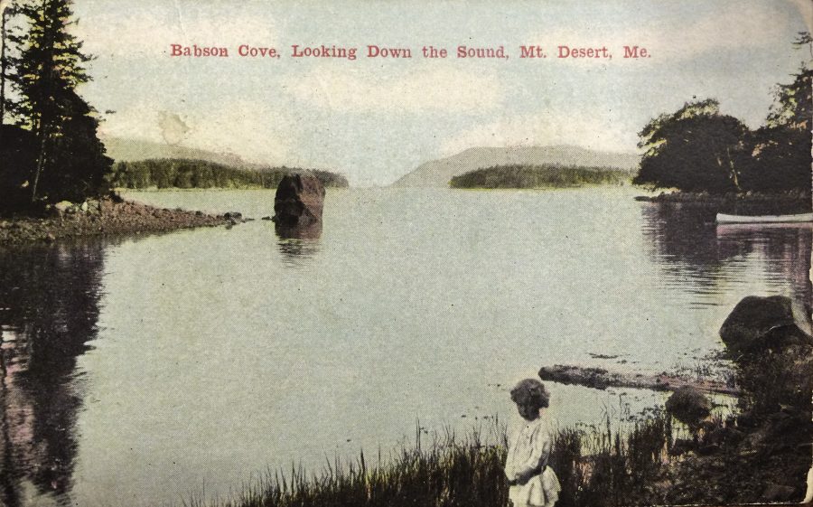


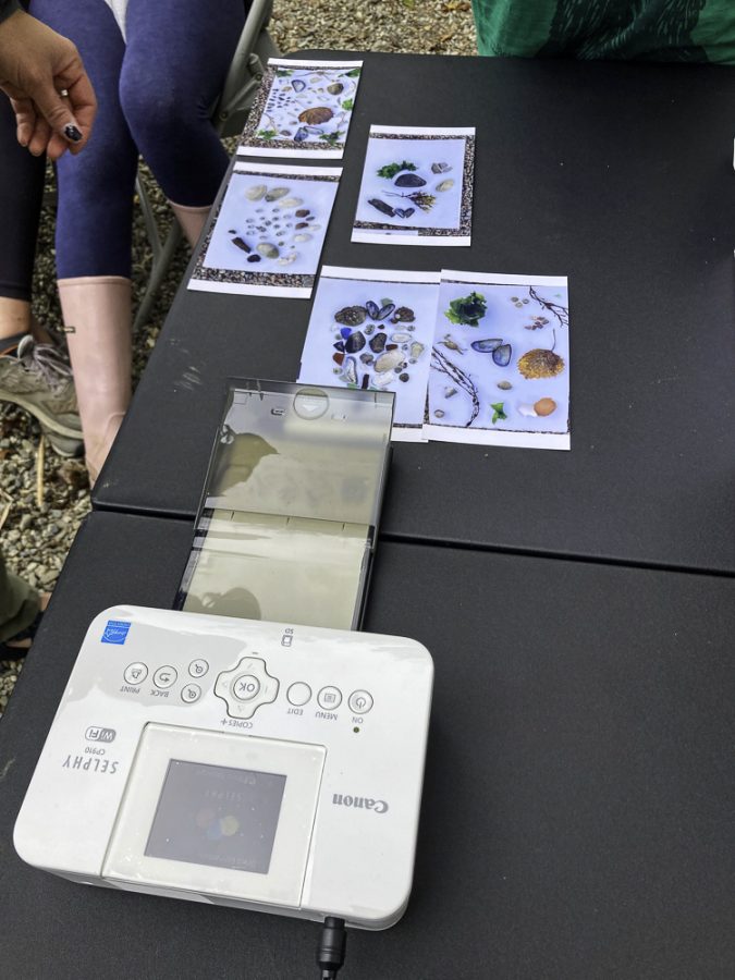


#/media/File:USS_Samuel_Eliot_Morison_(FFG-13)_underway_during_sea_trials_on_10_June_1980.jpg)