What I did last week instead of writing the next blog post – put on my Acadia-National-Park-Artist-in-Residence hat and gave a slide presentation at the Schoodic Institute. It’s about half an hour long:

I forgot to mention that I’ll be giving a talk about the Coast Walk this coming Saturday, September 26, 7pm, at the Schoodic Institute. It’s part of being an Artist-in-Residence with Acadia National Park. Details are here: http://www.schoodicinstitute.org/event/coast-walk/
I’ll also be speaking at the Bar Harbor Historical Society’s annual meeting on October 4. Different audience, so I’ll be talking more about the history than the natural history.

July 31, 2015: 4:41-7:30pm, 85ºF, light breeze from mouth of cove, a few puffy cumulus clouds in deep blue sky. Grasshoppers, no-see-ums, bald eagle, green crabs, at least 14 dead Moon Jellies (Aurelia aurita), Sand Shrimp (Crangon septemspinosa), 4 dead and 1 live Rock Crabs (Cancer irroratus), 3 herring gulls, 4 crows; heard 2 chickadees and a loon but didn’t see them.

Some of my posts take you to places you wish you could see but can’t reach without scrambling down cliffs, or along private properties you can’t walk without permission from the owners. This one takes you someplace you’ve never wanted to go: it’s the first mudflat of the Coast Walk! I know I’ve driven past the Inner Cove many times and it looked so unappealing: squishy and buggy and boring. Come on, let’s take a closer look…

It was a gorgeous, hot, late afternoon when I parked at the fish house landing and headed toward the causeway. I last walked through here in late May and the change in traffic was impressive. In May I had the place to myself, but in July the causeway was lined with cars and there were beachcombers everywhere. I knew it was irrational, but I found myself resenting them anyway. After the long, solitary winter it still seems strange to find the shore so crowded. When I crossed the causeway and climbed down onto the mudflats, though, I was alone again. I can’t imagine why the tourists weren’t swarming on this side:

Look how clean and white those sneakers are! You’ll see how long that lasted … The upper edges of the cove were filled with grasses and sedges and several large patches of these two plants: on the left is Sea Plantain (Plantago maritima) and on the right is Sea Blite (Suaeda maritima). I see them a lot along the high tide line and in the spray zone.

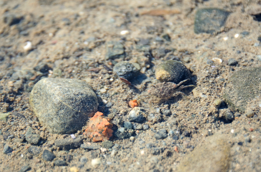
It was very quiet as I moved down into the empty cove: I could hear water trickling from all directions and the occasional bubble popping in a puddle. Walking across the flats there were sign of worm-life everywhere. I wish I knew more about marine worms; if only one of my mud-flat-loving friends could have come with me.

The mud in this area was solid enough to walk on (mostly), so I hung out for a while by the edge of the stream of brackish water trickling through the east side of the mudflats. It was full of life – periwinkle grazing, tiny crabs, translucent sand shrimp, and a lot of tiny shrimp-like things that I couldn’t see properly. [If you come on a Coast Walk with me, be prepared to squat for 20 minutes watching practically-invisible half-inch-long translucent things whizz around in puddles while mud oozes into your sneakers.]

This is a Sand Shrimp (Crangon septemspinosa):

It’s in the very center of the photo. Maybe this will help:

Better? Full disclosure: I had no idea what these were, so I posted the photos on Facebook and a bunch of my better-educated friends set me straight.
There were crabs of all kinds, from the size of my pinkie nail to the size of my palm. At the time I thought they were all Green Crabs, which was depressing, but looking at my photos I see at least two other species. I think this one might be a rock crab, but can’t quite tell – it was smaller than a periwinkle! And underwater, too.

Eventually I got a cramp and had to start moving again. The mud quickly got too squishy to walk on so I moved a little higher on the shore where it was rockier. I wasn’t trying to keep my feet clean; hoping to hike a mudflat with clean feet would be kind of delusional, but have you heard the term ‘honeypot?’ It’s a wetter, stickier area in a mudflat that you find mostly by stepping into it and finding you can’t step out. I was hiking in sneakers [still hadn’t bought proper boots to replace my deceased pair], and I was trying to avoid losing them in the mud.
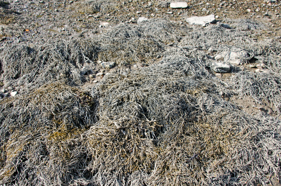
The rockweed that had been exposed by low tide was pale brown and dusty looking, covered in what I think was dried silty clay that must have been stirred up by the tides, suspended in the water, and deposited as the tide receded:
A whole swarm of Moon Jellies (Aurelia aurita) had washed up in the rockweed. I counted 14 in this patch – all sizes from softball up to dinner plate.

See those four white things in the jellyfish? Those are its gonads. Jellyfish don’t have a lot of internal structures – the part we think of as the ‘jelly’ acts as their lungs and their digestive system (it’s called the “gastrovascular cavity“) and they don’t have a circulatory or excretory system (no blood or poop) – but they do have a reproductive system. Those moon jellies have very clear priorities.
Also notice the crust of mud beginning to creep up around the edges of my sneakers.

Those “bugs” on the jellyfish are springtails. Remember way way back on Schooner Head when I lectured you about decapods and amphipods and Latin names based on Greek adjectives? So springtails are hexapods. Hexapods were once considered insects but are now their own separate thing, which is why I had to put quotations on the word ‘bugs.’ Hexa comes from the Greek word for six and pod comes from the Greek word for foot, so yeah, the hexapods have six legs. Just like bugs! But they’re not bugs because science. There are a lot of different species of springtails (“a lot” is shorthand for “I couldn’t find a specific number”) and Wikipedia estimates there are 100,000 individuals per square meter of ground anywhere on earth where there is soil. Let’s pause to consider that. Different species have adapted to different environments – you’ve probably seen snow fleas in the winter? Those are springtails, too.
These particular springtails are Anurida maritima, a species adapted to the intertidal zone. You often see them in masses on the surface of tidepools. Their bodies are covered with hydrophobic hairs that let them move around on top of the water. (Hydrophobic in this case is a chemistry term meaning the hairs effectively repel water.) Here they are performing their function as scavengers, helping break down organic matter (aka dead jellyfish).

The shore started to get rockier, and I found animal scat on top of the stones, out in the open, just above the high tide line. Again! Wish I could figure out what animal does this. There were several piles of similar shape but with varied content – one was white and seemed to be mostly thin shell fragments like crab carapaces, another was dark and appeared to have seeds in it, and the third

was brown and full of stuff that looked like insect bodies. Maybe chitin is indigestible?

Jumping from decomposing jellyfish to macro photos of poop – are you thoroughly grossed out yet?
You’re welcome.
[Nov.29, 2015 – Pretty sure it was either otter or racoon scat.]
Just past the poop, the shore was covered with old quarry stones,

which must be the location of Ans’ Wharf on this map:

detail of “The Village of Otter Creek,” hand-drawn map by Karen Zimmerman. Available here. This is a great map if you are curious about Otter Creek history. Karen is a graphic designer who lives in Otter Creek and has become sort of an unofficial historian of the town. This is only a little bit of the map, and the rest of it is just as packed with interesting tidbits. My favorite is the midwife’s house: “over 75 babies born here!”
Ans’ Wharf is named for Ansel Davis, who fished out of the cove in the 20th century. Davis’ house was up the hill from the wharf. He also had a fish house next to the Walls fish house we saw on the east side of the cove (labelled “fish houses were here” on the map.)
The wharf was originally built in the 1870s for Cyrus Hall’s first quarry on MDI. Yes, the first “Hall’s Quarry” on the island was here in Otter Creek! So was the second (across the cove on the west side.) The town we currently know as Hall Quarry, over on Somes Sound, was Hall’s third venture, begun in 1883. You can see the first quarry on this 1887 map:

Image courtesy of the Library of Congress.
Cyrus James Hall was born outside Belfast (Maine, not Northern Ireland) in 1834, taught school for a while, then started a lumber and granite business in Belfast. We’ll talk a lot more about Hall when we reach Hall Quarry, but various sources describe him as well-dressed with scholarly interests, but tough and hands-on in the quarry.

Cyrus J. Hall. Image courtesy of the Maine Granite Industry Museum.
Hall came to MDI looking for a better grade of stone, and settled on the distinctive pink-red granite of Otter Creek. He formed the Standard Granite Company in 1870, and the Otter Creek quarry began production in 1871. Eventually Hall recruited experienced stonecutters and quarry men from Italy, Scotland, Finland, and Sweden, and Otter Creek became a bustling commercial center, sending granite all over the East Coast. OC granite was also used in the Northeast Harbor Episcopal Church.
I’ve been hunting for old photos for several weeks (one reason this post has taken a month to write) but the photo below is the ONLY one I could find of Otter Creek Cove during the quarrying period, and nobody seems to know who took it or when. I struck out finding anything else at the MDI Historical Society, the archives of the Northeast Harbor Library, and even the Maine Granite Industry Museum!

In this early photo of Otter Creek Cove, a schooner is docked at the approximate location of Jimmy’s Wharf on the west shore. A fish house is visible on the east shore. Image courtesy of the Northeast Harbor Library.
I can’t see it in the photo, but apparently the shoreline was full of quarry-related structures: wharves, roads, derricks, pens for the oxen who pulled the loads of granite around, and so forth. According to Deur (source listed below) “Hall’s men constructed wharves from natural rock ledges … on either side of Otter Creek cove. Modern residents refer to the initial wharf constructed on the eastern side as “An’s Wharf,” while the wharf for the quarry on the western side was called “Jimmy’s Wharf.” A third wharf, Grover’s Wharf, operated near the west-side fish houses for a time… . Shipping of granite was, at best, difficult from this small and shallow cove… . Ships loading granite from the quarries commonly were allowed to become grounded at low tide, were loaded in this condition, and then floated free with their loads on the rising tides… . During the quarrying, ships filled Otter Creek. At times, there were ships at both An’s Wharf and Jimmy’s Wharf simultaneously. At other times, ships were aligned to fill the bay from one wharf to another – perhaps in an effort to minimize listing of ships while they were loaded at low tide. As explained by Norm Walls, ‘all the way across Otter Cove on the inside of [what is now] the Causeway. My grandmother…told me that she could [practically] walk from this side to the other side across boats. They would be tied up in there waiting to get loaded with stone.’ ”

An abandoned road leading up the hill from Ans’ Wharf.
Otter Creek granite was not only distinctively colored, it was one of the hardest stones quarried in Maine. The hardness of the stone, which wore out tools and slowed work, and the difficult harbor limited the production possible in the quarry. (Deur again:) “Drills and other tools had to be sharpened and repaired almost constantly. … Even when operating at breakneck speed, an entire tidal cycle was required to load a ship with granite, and typically only two ship loads of stone could leave the cove per day.” Once he opened the quarry on Somes Sound, Hall sold off his Otter Creek property to smaller companies. “Comparatively small-scale quarrying operations persisted, some under the direction of J.S. Salisbury. Salisbury resumed some of Hall’s aggressive marketing of the distinctive Otter Creek granite, successfully selling numerous loads to builders in Boston and other Northeast cities through the late 19th century, though production at the quarries tapered off considerably by the late 1880s. … Salisbury maintained quarrying operations until the beginning of the 20th century. After that time, the quarries were largely disbanded, with small-scale quarry operations emerging occasionally for local stone projects.”
[Sources for the above include C.V. Truax, “The Pink Granite of Somes Sound,” Downeast Magazine, Oct 1972; Douglas Deur, The Waterfront of Otter Creek: A Community History, National Park Service, 2012; Steve Haynes, Maine Granite Industry Historical Society website, and 2 unpublished manuscripts in the collection of the MDI Historical Society.]
At the risk of making this post unreadably long, I have to tell you about the Maine Granite Industry Museum.
 As I read through the chapter about the quarries in Deur’s book, I kept coming across quotes from Steve Haynes, so I did a little research and found he is the guy behind this museum. It’s on the Beech Hill Crossroad in Somesville, and I’ve driven by it a few times over the years, always thinking I should stop and have a look, but of course I was always in a hurry to get somewhere and then forgot about it as soon as it was out of sight. You know how things go. Well, damn, but I had missed out! This place is amazing. It’s not big and it’s not fancy, but it sure is comprehensive. The walls are covered with historic photos of quarries all over Maine, and photos of the people who owned them and worked in them. Steve has been interviewing former quarry workers for years, and man, would I love to go through his archived material. He’s working on a book, so one of these days we’ll all get to read it.
He made this map showing all the quarries he’s documented on MDI:

There’s a stone sample for each quarry:

Steve has located the old quarries on the map with samples of the stone. It was fascinating to see how the color and texture of the granite changed from place to place. But wait, there’s more.

Steve Haynes demonstrates quarrying techniques at the Maine Granite Industry Museum.
He showed me the tools the workers used to quarry stone (yes, he’s collected historic tools, too.) You know how my mind gets boggled at least once on most Coast Walks? This was the moment. See the squarish hammer and the long piece of iron lying on the table at the right? When books talk about “drilling” in the old quarries, well, that’s the drill. One guy would hold the iron rod at the point where they wanted to make a hole, and another guy would whack it with the hammer. Hard. Then the first guy would turn the rod slightly, and the second guy would hit it again. Turn, hit, turn, hit. Eventually they would have a hole. You say the word “drill” and I picture a machine. Something with gears, at any rate. Not two guys and a piece of iron! Every single building ever built before, what, the 1880s? – the stone came out of the ground like that. One whack at a time. At least in the 19th century they could put blasting powder in the holes.
 These are tools for finishing the stone – splitting it, adding a texture to the face, or polishing it. I’m sorry I didn’t get a closer picture of this, but see the gray rectangle of stone on top of the granite block at left? That’s emery. Steve said emery has been quarried in Greece for thousands of years. It is about a 9 on the Mohs scale (diamond is a 10) and is used for polishing stone. Like this: you take that block of emery and rub it against the granite for a few hours. There’s a technique to it, obviously, but that’s what it comes down to. Patience. Steve has samples of stone from all the quarries he’s documented. You can kind of see them on the tables around the walls in the top photo. He polished every one of them by hand. I’m just going to pause for a minute while we think about the time and labor involved.
And then we’ll get back to the mudflats. The shore got progressively steeper as I moved north toward the creek mouth. I don’t know when the stone was put there, but it all seems to be quarried, so I’d guess it’s been there a while:

I had a moment of humility right here but I didn’t know it until I got home. You know how I’m all ‘I’m an artist, I’m so observant, I’ll show you cool places and things you haven’t seen?’ Well! I was trying to photograph the gulls flying around, but I was shooting into the sun and couldn’t really see what I was shooting. None of those photos came out well – surprise – but when I looked through them on my computer I found this:

A bald eagle had been watching me the whole time.
After not-seeing the eagle I saw this:

A skeleton out in the middle of the flats.

What do you think – small deer? Medium size dog? No skull anywhere, sorry.
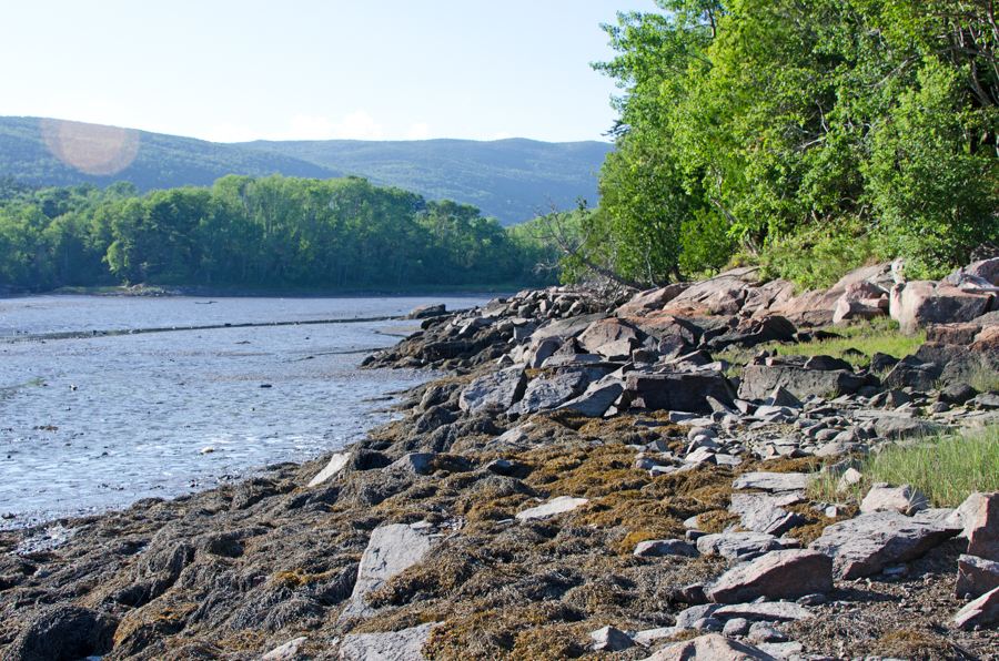
By now I was getting really close to the mouth of the creek and the shore was flattening out. The alders dipped so low over the cove there was rockweed tangled in their branches.

Looking back toward the causeway from the mouth of Otter Creek:

What’s that you say, it looks like an empty swimming pool? Funny you should say that. I’d heard John D. Rockefeller, Jr. wanted to make this a swimming area when he had the causeway built, so I did a little research and found some interesting info. [The quotations and most of the info that follows come from Otter Creek Cove Bridge and Causeway, Richard H. Quin & Neil Maher, Historic American Engineering Record, 1995.] Point one is that Rockefeller didn’t build the causeway. Oh, he built the roads on either side, commissioned the design, and hired Frederick Law Olmsted, Jr. to review it, but for some reason he moved on to other projects, and the causeway was paid for by the Park Service and constructed by the Bureau of Public Roads, a government agency that had a contract for building roads in the national parks at the time (and which eventually became the Federal Highway Administration.) The BPR also built the road up Cadillac. Point two is that yes, a number of people thought this would make a good swimming area, and the arches under the causeway were built with slots for boards that would hold the water in the inner cove. (Look at the bottom right corner of the drawing below.) They are still there. The Inner Cove could made into a swimming pool tomorrow. In theory.
The lead engineer on the design was Leo Grossman of the Public Roads Administration, and the contractors were Sammons, Robertson & Henry, of Huntington, West Virginia, and J. M, Francesea & Co. of Fayetteville, West Virginia. I have to admit, when I read that they’d brought contractors in from Away, I thought, ‘and what were the local builders, toast?’ I mean, the quarry just up the hill had only been closed for maybe fifteen years.

The HAES survey had a ton of technical detail, and I was tempted to quote the whole thing, but I guess I’ll take pity on anyone who doesn’t care about the relative cost of a bascule bridge as opposed to masonry-faced earthwork. If you want to geek out you can find the full report here. The report summarizes the causeway’s construction method: “The entire structure is 215′ in length with a bridge span of 62′. The middle of the three arches is 15′ wide while the two side arches are each 12′ wide. The structure is constructed atop a natural bar which extends nearly across the upper part of Otter Creek Cove. It features a concrete core wall through part of the bar to prevent water from undermining it; otherwise the bridge is of nearly solid masonry construction. This contrasts with the other bridges on the system, which are generally reinforced concrete bridges faced in native granite. In this case, stone construction was adopted because of fears that salt water would cause deterioration of a concrete structure. The central or “bridge” section of the structure is comprised of solid stone masonry arches. These are covered with a Class A concrete backing, troweled smooth, over which there is a waterproofing membrane. Above this is a level of stone or gravel sheathing, and then a compacted earth fill between the arches and the spandrels. Above this is a standard bituminous asphalt roadway surface. The Otter Creek Cove Bridge and Causeway is essentially a filled spandrel arch bridge with causeway extensions to either side.”
There were several prior attempts to build a bridge across the cove, beginning in the late 1880s. All of them were destroyed in storms. Sometime after 1913, Hancock County finally built one that lasted more than a few months. “This structure was 625′ long and consisted of a 555′ wooden trestle bisected by a 70′ pivoting swing bridge. The central stone-filled crib pier of the swing bridge was bordered on either side by two 30′ channels, while the ends of the swing spans rested on granite abutments. The connecting trestle, standing some 22′ above the water level, was constructed on the north end on a natural bar composed of sand, cobbles and boulders thrown up by the sea.”
You can see the existing bar in this photo – looks like it ran halfway across the cove. Image courtesy of the Northeast Harbor Library
The swing-span of the bridge began to fall apart by the 1920s, when Rockefeller was working on the Park Loop Road plans. “In August 1925, Rockefeller employed the J. G. White Engineering Corporation of New York to inspect both the cove and the old swing-span bridge. The firm reported that the bridge’s trestle, although in a “considerably decayed” condition, was nonetheless intact though the swing-span had disappeared. The central pier remained, although it too was in a dilapidated state. … The bar across the cove was described as approximately 500′ long at low tide and 350′ wide, and the creek channel was measured as 55′ wide and 4′ deep.”

Image courtesy of the Northeast Harbor Library
“… The J. G. White report recommended that the new bridge should be constructed immediately south or seaward of the existing trestle and bridge. The natural bar, the report suggested, would offer protection for any structure built upon it. … In the fall of 1925 the company conducted a second series of surveys and borings and reported in December on physical conditions at the site. … Borings in the channel bar revealed its composition as a 1′ layer of cobbles and small boulders underlain by 4′- 8′ of sand which rested on soft blue clay. Beneath the channel itself, rock was struck at depths ranging from 2′-14′. While most of the rocks had probably been deposited by storm tides, a granite ledge was clearly evident about 12′ beneath the trestle’s west abutment and served as its foundation.”
“The White Engineering Corporation [proposed] a “causeway-dam.” … This option would also feature a spillway near the middle of the structure… . The spillway would ordinarily be closed with stop logs to an elevation of about 1′ below high tide. This would trap sea water behind the structure, creating a pond or pool which could be used for swimming. The stop logs could be adjusted for height of tide, or to adjust clarity or levels of salinity. The depth of the “pool” would range from 0′ at the shore to about 14′ in the channel. … The company again suggested that if a dam were to be constructed it would be necessary to obtain all riparian rights above the structure, and the permission of the War Department would have to be secured for any structure as the cove was technically an historically navigable body of water. …”

Image courtesy of the Library of Congress
“Over the next four years, Rockefeller’s chief local concern was the extension of his comprehensive carriage road system and the continuation of work on the park motor road system which ultimately evolved into the Park Loop Road. In 1930, he engaged noted landscape architect Frederick Law Olmsted, Jr. to study the Otter Creek Cove crossing, and provided him with copies of the J. G. White reports. He evidently told Olmsted that he was interested in the concept of impounding the cove to allow for swimming, as ideas concerning the measure appear in the reports. Olmsted surveyed the cove in March 1930. He agreed with the White Corporation engineers that the road should be built across the bar and not run around the head of the cove far to the north. … Yet whereas the White company’s proposal envisioned the causeway as cutting straight across the bar, Olmsted recommended that it be curved. Olmsted also … recommended lowering the structure about 3′ for “reasons of appearance rather than economy.” A separate channel, he argued, could be constructed for Otter Creek if it was determined that fresh water entering the head of the cove might “pollute” the salt water behind the dam (bacterial growth is hampered by high salinity, while fresh water encourages it). This water in this “scenic pool” behind the dam, Olmsted believed, would warm enough during the summer to permit comfortable bathing while a “much-to-be desired sand beach” could be developed against the outer wall of the raised bar, adding to the pleasure of the bathing pool on the other side. … In conclusion, Olmsted summarized his views on the matter. ‘I would recommend without hesitation the construction of a solid fill causeway across the inner bar for the road-crossing with the incidental formation of a sheltered and sun-warmed tidal bathing pool behind it, as giving both the most agreeable solution of the whole problem from a landscape point of view and one of the least costly solutions that would be reasonably satisfactory.’ [Frederick Law Olmsted, Jr., “Special Memorandum in Regard to Crossing of Otter Creek Cove,” March 1930. Acadia National Park Library.]”
“By the mid-1930s, Rockefeller was withdrawing from further work on the park motor road system. Although he financed the construction of the Ocean Drive and Otter Cliffs sections of the Park Loop Road, he ultimately declined to construct the Otter Creek Cove Bridge which would have connected the two segments. The National Park Service turned to the Bureau of Public Roads (BPR) … BPR structural engineers concluded that the causeway should be constructed of dumped rock with large blocks on the outside. Instead of a clay core, they suggested a thin concrete core wall rising only to within a foot of high water, the maximum height thought desirable to hold back tidewater in the basin. Clay, they believed, was liable to erode from tidal ebbs and flows in a loose-jointed rock structure. The openings, which could be closed with stop-logs, should be located in the deepest part of the channel. This would allow small boats without masts to pass through if the openings were left open, negating any legal objections regarding navigation. … Olmsted met with Rockefeller in late November 1935 and secured his acquiescence to these revisions. The Bureau of Public Roads began preparing new plans for the Otter Creek Cove Bridge and Causeway during spring of 1936.”
“In its 1937 appropriation, the National Park Service secured $500,000 for the construction of the Otter Creek Cove Causeway and the adjacent Black Woods section of the Park Loop Road. With the funding assured, Rockefeller transferred the adjacent land to the government so the road project could proceed.”
“To determine the final location for the route across the cove, BPR engineers established a location line approximating the curved top of the bar. Since the bar was composed of rounded stones or cobbles, the top surface of which shifted with the tides, it was necessary to determine if the bar could permanently bear the roadway. The engineers staked a line across the bar from shore to shore, then took borings every 50′ along the line. As they had no power equipment, the engineers acquired a supply of used pipe and used local laborers to drive the pipe to the bottom. Once the information was tabulated, it was decided to construct a long concrete core wall to serve as a spine to prevent the undermining of the structure. Stone riprap would be used to protect the fill on the ocean side since it had also to be placed on a relatively flat slope to minimize damage from the waves. … The structure was completed in September 1939 and the Otter Creek section of the Park Loop Road was opened to traffic. Rockefeller notified Olmsted that the road had been opened and wrote that he was especially pleased with the causeway, stating that it “looks as if it has always been there, so naturally is it related to the surrounding country, while the curve only adds to its beauty.” He added that motorists were delighted with the road, and congratulated Olmsted on his role in the successful design of the structure. Despite the intentions of Rockefeller and his planners, and the provision for stop-boards in the three bridge arches, the structure was evidently never used for impounding waters in the cove. It is very likely the Park Service would have objected to the concept of an artificial swimming basin as inappropriate for a national park and would have ordered the stream flow left unobstructed.”
We now return to our regularly scheduled program.

The mouth of Otter Creek as it enters the cove.
The sun went behind the hill as I rounded the end of the cove and the temperature dropped about ten degrees. (Not exaggerating: it had been 85ºF when I started at 4:40pm, and was 76º when I reached my car around 7:30.) It’s amazing how cold 76º feels when you are sweaty and tired and in the shade!
There was a surprising amount of industrial debris at the mouth of the creek. I’ve heard engines were sometimes used as moorings:

The mud there and along the west side felt like clay, and you can see how the rocks were covered in a thin coating of it. Now we can add clay to the list of slippery things that cover the rocks I’m walking across (seaweed, algae, and ice so far.) My sneakers were already soaked, so I stood in the channel to rinse off some of the clay:

Just around the curve of the cove’s head I found the Otter Creek town boat ramp:

I never did find the landward entrance to it. There were some pretty waterfalls in a little cove just north of the ramp. You can probably tell from the photos that twilight was falling here on the shadowed side, even though the east side was still brightly lit.


As I got past the muddiest area, I had to get through a stretch of rockweed-covered boulders.

Usually I deal with tricky ground like this by finding cracks or spaces between boulders to brace my feet, or I jam them into crevices. It works well with boots but was really painful with sneakers! By the end my right arch was aching, I was limping slightly, and my left toes all bruised. No more hikes til I get proper gear! Eventually I reached Jimmy’s Wharf (see Karen’s map way way up above).
“Jimmy’s Wharf – A stone wharf formerly used for transshipment of granite from the Hall quarry on the west side of Otter Creek cove. The identity of Jimmy remains unclear, except that this was a resident who used this point for water access at this point following the peak of quarrying in the late 19th century.” (Deur, p.24)


I was slipping a lot by this point, maybe because of the clay and the treacherous ground, but maybe because I was getting tired. I try to be sensible about my limits – it would be SO EMBARRASSING to have Search & Rescue come and bail me out if I sprain an ankle being stupid! I also knew that not far past the wharf the shore turns into sheer granite cliffs right up to the causeway tunnel, so I scrambled up the hill looking for a trail marked on my map.
 Found it. Terrible photo, I know – it was really dark in the woods by this time. The path I was on intersected the Quarry Path at its southern end. This is a new trail in Acadia, and is pretty cool:

“The brand-new Quarry Trail and Otter Cove Trail—connecting Blackwoods Campground with Ocean Drive and the Ocean Path through Otter Cove—were opened on National Trails Day, Saturday, June 7th … Visitors camping at Blackwoods can now access the very popular and scenic trails on Gorham Mountain, the Beehive, Champlain, and beyond, without getting in a car nor even walking along the Loop Road. The Quarry Trail … was built using an old road, which dates back to the era when granite quarried in Otter Creek would be loaded onto ships in Otter Cove. Many Otter Creek residents can remember taking the old Quarry Road to the shore for fishing, swimming, or just an enjoyable walk. In the Winter 2013 Friends of Acadia Journal’s “Where in Acadia?” feature, resident Rick Higgins remembered childhood swims from Jimmy’s Wharf as the tide came in, because “the water would be much warmer from the sun beating on the mud flats.” Fifth-generation resident Dennis Smith recalls that some of his first memories are of walking down to the causeway with his babysitter and fishing for pollack—he says he’s “been a fish fanatic ever since.” Smith was interviewed for a Friends of Acadia video about the trail (it can be viewed at vimeo.com/friendsofacadia) in which he noted that his grandfather used the Quarry Road when cutting firewood in the park—an activity frowned on by George Dorr, much to the grandfather’s disgust. Smith chuckled at the memory, recognizing that although past generations had to give certain things up when the park was formed, today’s generations can easily see all that has been gained in return.” [“Old Roads to New Trails,” Thomas & Church, Friends of Acadia Journal, Fall 2014.]
The trail curved down the hill and I limped out onto the causeway, splattered with mud up to my knees, limping and vowing to get a decent pair of hiking boots in the morning. This is beginning to seem normal: the Coast Walks always seem to start out with me chasing random grasshoppers for a good photo and by the end I’m so tired a whale could breach and I might not care.
In the next installment, Karen Zimmerman takes us INSIDE the Otter Cove fish shack. Stay tuned!

Walls fish house circa 1968. Photo courtesy of Cynthia Lawry.
May 11, 2015: 10am-noon, low tide at 11. 57ºF, overcast, chilly, some wind. 1 Wild Turkey (Meleagris gallopavo), several Herring Gulls, 3 bicyclists, 1 Eider, 2 black duck-like birds far off in the distance (probably Black Scoters), 2 Laughing Gulls (Leucophaeus atricilla), 1 Downy Woodpecker.

Walker: Cynthia Lawry
Throughout her childhood, Cynthia spent summers in Otter Creek with her great-grandparents, Chester and Myrtle Walls. She lives in Gloucester, Massachusetts now, and we met at the Fabbri Memorial on a damp, cold, grey day in May to talk about the family fish house and her memories of growing up here. Looking out across the cove, Cynthia pointed to the existing fish house.
Cynthia: That fish shack was not there [on the opposite side of the cove] when I was growing up. We had the fish shack over here [on the east side of the cove], and then the National Park came in, there’s a lot of crazy stuff, and that was torn down, and then all of a sudden the Smiths built that.

Fish house on the west side of the cove: built by Steve Smith in 1976, burned and rebuilt in 1983, now owned by the Otter Creek Aid Society.
Jenn (me): And roughly when was this, the ’70s?
C: Yeah. I think this [the Walls fish house] was torn down early ’70s. And then that appeared. …My great-grandfather, Chester, had a forty foot lobster boat in here, and he would haul it right there, in front of that big rock, and do his repairs. One of my earliest memories is him taking me out and handing me a boat hook, and us being off the Point, and him saying “Fend us off the rocks!” And I was, you know, this big [holding her hand at about waist height] I was very tiny, I couldn’t even really lift the boat hook, and thinking, “We’re going to die if I don’t do this.” He was a really wonderful man, he was deaf by the time he was 14, I guess he worked in a lot of engine rooms, and they’re very loud, and he was really deaf. You had to really scream to get him to hear you, but very kind. I think his deafness kind of separated him a little bit from the world. I grew up listening to he and his half-brother [Harold]; Chester’s mother died at some point, his father’s name was Willis, and Willis married another woman and had Harold. So Harold was a lot younger. They both shared the shack that was down here, and they had two slips. Let’s go wander over there!
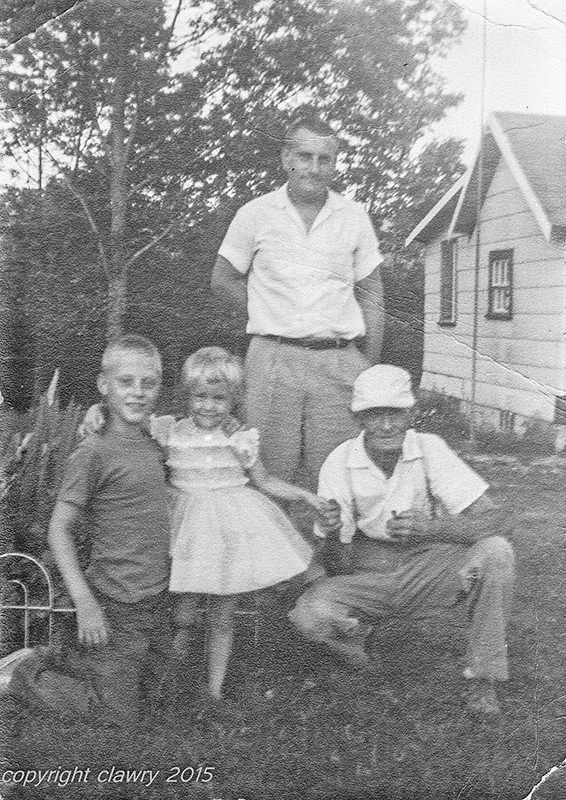
Left to right: Philip Lawry, Cynthia Lawry, David Lawry, Chester Walls, taken about 1961. The house in the background belonged to Ida Walls Seeley, one of Chester & Myrtle Walls’ daughters. Photo courtesy of Cynthia Lawry
C: So this is the old road that goes down in [ed.note: not marked but called the Fish House Road or Fishermens Lane]… there’s a crabapple tree that my grandfather planted that’s still there.

Cynthia’s grandfather’s crabapple.
J: So how long did you live here?
C: I had a grandmother who lived in Newton, and it was felt when I was about 6 that it would be best if I lived there. I spent every summer here, and I learned how to lobster from my great-grandfather, and set trawl. These are where the boat slips were. This one, where the memorial piling is, for my Uncle Harold, that was his boat slip.

Photo from Deur, The Waterfront of Otter Creek, 2012.
There’s a poem on the other side of it that he wrote. He was self-educated. I think he might’ve gone through the eighth grade, but he read and wrote beautifully. I do have some of his letters, I’ll have to dig them out because they are really spectacular.
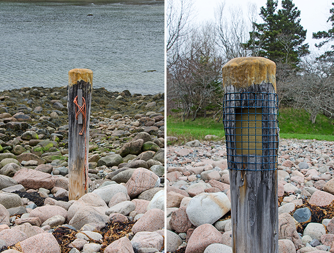
J: I’d love to see them. [looking at the other side of the piling, where the poem is set into the wood.] Oh cool!

“Picking the Slip” by Harold Walls
C: His son, Bobby, did this.
J: Now is that Bob Walls who manages Mrs. Pyne’s place?
C: I think so, I haven’t seen him in years.
J: Probably seven years since I saw him last. And his brother’s Don? [If you guys are reading this, hi Bob, hi Donnie, it’s been way too long!]
C: I grew up with them. My great-grandfather lived at what’s now 169 Otter Creek Drive, and they lived across the road and a little bit towards town. My aunt lived in the next house over, my grandmother lived in a house towards Otter Creek.
J: So they’re your cousins?

Photo from Deur, The Waterfront of Otter Creek, 2012
C: Yes. …And then Harold’s boat slip was here. They would moor their big boats out in the middle, because at low tide there’s a very small channel to get through. … Harold wrote a poem about ‘picking the slip’ because it was our job to come down here and pick the rocks out of the slip so they could get up in there. As you can see it hasn’t been done for a while. We used to drive an old truck and back a boat in. I don’t know why they settled this area, it seems insane to me because of how inaccessible it is to the water. It’s not an easy place to fish. To get in and out of.
J: It looks like it’s wide open, but it sounds like its actually really hard to get in and out.
C: I used to be able to take a motorboat in and out of here without killing the propeller, but my father couldn’t. We would go out and set trawls, tub trawls, for halibut, and he’d set off the Sand Beach; from the Soaker in to the Sand Beach is a really good place, or it used to be, and he had my great-grandfather’s chart that he had all marked up and his old gimbal compass, and I don’t know what my visual reference points were, but I could get a boat up, whereas my father ruined more than one propeller.
J: So did he grow up here?

Looking southwest past the Harold Walls Memorial Piling and the former site of the boat slip to the OCAS fish house.
C: No, my father is a Lawry, and his family was from, well, he actually grew up in Newton, his father was from Farmington, and he was in World War I, but that’s a Farmington story, that’s not an island story. This is the rock that I spent my childhood on [just past the piling in the photo above, it is surrounded by water at high tide. You can see it in the older photo just above as well.]
J: No kidding! I can see why, it’s awesome.
C: It’s got great tide pools on it. When I would be let loose here a lot of times I’d sit on this rock.
J: I’m a sucker for tide pools, you’ve probably noticed that.
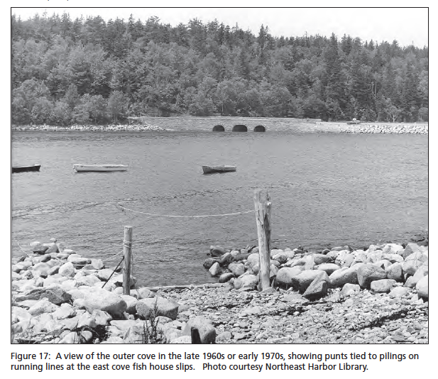
Photo from Deur, The Waterfront of Otter Creek, 2012
C: And at high tide you have to swim to get off this rock. It has happened. If you were a little kid and you had to pee, you came up on the rock. Out of sight. This used to be a little more thriving. There was a guy named Shirley Bracy, and he was a clammer and he was a character. He would always come down and they would jaw as they were fixing nets or whatever they were doing, working on the boat. The fish house was right there, and it had two large wooden barrels of lobster bait, and I’m pretty sure that stuff had been in there since the 1700s.
J: That smell, huh?
C: We would go out and we would catch halibut off the Point, over there, and bring it back and just kind of throw it in the barrel, stir it up a little bit, you know,
J: Kind of like a sourdough starter, you just keep adding to it.
C: It was absolutely horrible.
J: How did they keep animals out of it?
C: It all locked up and shut up … and the barrels both had heavy lids on them, wooden lids. It was a stinky mess!

C: When I was a kid we would clam over here towards the road [the muddy area by the causeway] , and since I was under a certain age, I could dig a peck of clams a day without a license.
J: Wow, that’s a lot of clams, isn’t it?
C: Yep. And I liked fried clams, but my father really like steamed clams, so I would dig and he would eat. But it was fun, it didn’t seem like work.
J: Did he ever fry them up for you?
C: Once in a while someone would fry them for me but for the most part no, they were always steamed. … I heard that back in the day the mackerel would run in here, and they would sort of net a part of it off and row out … . Once when I was a kid and I think we were out fishing for pollock, and it was really foggy, a lot of times it’s really foggy in Otter Creek and you just go round and in Bar Harbor it’s clear as a bell. It was magical to come down here in the morning and have the fog. Once we got blown off, and I remember my father saying to me, ‘Well, the next stop is Europe.’ If we don’t figure this out, where we are, we’re going to Europe. It was foggy and windy and I thought for sure we were going to Europe. But we saw a lobster buoy and knew we were headed in the right direction. I wonder sometimes, how much was he pulling my leg and how frightened really was he?

Photo from Deur, The Waterfront of Otter Creek, 2012
C: …In addition to fishing for flatfish, groundfish, [Chester and Myrtle] farmed, and he had two acres of raspberries, I grew up picking raspberries, we would sell them to Testa’s, they would make raspberry pie. I remember going in and delivering the rasbperries when I was a really little kid, and the whole kitchen was stainless steel.
My great grandparents were first cousins, because the wife of Willis was a Davis, and my great grandmother was Myrtle May Davis. Myrtle and Chester Wallace. They had three daughters, they had my grandmother, Ida, and they had Aunt Madeline, and Aunt Clara. Ida is an old family name that goes back in the cemetery way, way back. Anyhow, Ida was a very popular name, and I think it was popular just in that time.
J: Kind of like Jennifer now.
…
J: I don’t know if you saw the most recent [post] at Sand Beach, and there was the picture of a little girl, Virginia Higgins – one of my friends was like, ‘oh my god, that’s my great aunt!’ So she’s looking up the family history; Virginia Higgins … was a nurse in the Navy, I think. So she’s looking to find out more about what happened to Virginia and how she ended up in the movie.
C: My grandmother used to tell me about the movie. … My grandmother … grew up in town, on Ledgelawn [Avenue in Bar Harbor], other side of the family, [and she] played the piano at the theater for the silent movies, and when I would say ‘We’re going to the Sand Beach,’ when I was a teenager, she would tell me not to go swimming in the water because they used to make movies there and somebody dove off a cliff and was swept out to sea. I don’t know if that’s true, if that really happened.
J: There was a cameraman who got washed off; he didn’t dive in, he got hit from behind by a wave. I’m not sure if that was on Schooner Head or on Sand Beach.
C: That could’ve been the basis for that little cautionary tale.
J: There was definitely a death on one of the movies. Not on the Queen of the Sea, it was on a different one.

Photo from Deur, The Waterfront of Otter Creek, 2012
C: I have boxes of stuff from this side of the family and the in-town side of the family. They were prolific postcard writers. They would write a postcard from Otter Creek to Bar Harbor. Some of them are really nice old Maine postcards, and some of them are stupid, goofy stuff, just sort of humor from the era. And I really want to scan those and catalog them, because my background is, I worked at Cornell University in the archives. I was in the Rare Books and Manuscripts. I have newspapers from when my grandmother graduated from high school, [and] I have really cool stuff like they gave them these little fake torches, and just little artifacts. I’ve got a treasure trove of stuff like that … my great-grandparents, Chester and Myrtle, never threw anything out. They have receipts, they had a stand on the side of the road where they sold green beans and things, they have this all listed, the summer people they sold things to, they kept them in these little notebooks. When I was a kid I would go out and weigh beans and sell them to the summer people. That’s part of how they earned their living, because you couldn’t just do it lobstering.
J: Even today there are … few people who have just one job. [A lot of] people do this for a living and then they do that in the summer and that in the winter.
C: It pieces together. And here … then in the winter there was nothing. Everything closed. Now most everything closes, but there’s more stuff.
J: Well, winter’s when we see each other. Summer, everyone’s too busy to hang out. Winter is … plays and basketball and potlucks.
C: We would have picnics on the beach and sand in food. I just remember sand in cucumbers. And clamming, that was a really good place to clam. And I know Shirley Bracy used to clam. He died maybe ten years ago. When I was a kid I thought he was ancient. But he wasn’t.
J: When you’re a kid, forty years old looks ancient.
C: True. He would come over to Chester’s house at night. Chester had a big garden out back, and he would sit in his rocking chair with his .22, looking for deer. Harold would come over, and usually somebody else, there was a guy named Uncle Pete, and he was bald. I don’t think he’s any relation. He lived in Otter Creek. He had a daughter named Marcie who babysat me … . I just remember they were very nice to me. And they would come over and they would just talk over the day, about what fish they caught and things like that, just kind of hang out, and my great-grandfather would be looking for deer to shoot in the garden. He never did, but it was very impressive.
J: Was he hopeful that there would be a deer, or was he just trying to keep them away from his garden?
C: He was trying to keep them away from his garden. He had a fish shack at the house, too. He kept his tools and stuff. And on the door to that were two bear paws. Back in the day he shot two bear.

Photo from Deur, The Waterfront of Otter Creek, 2012
His family, they settled the island, there were three brothers, I believe [the father was] Andrew Wall, and he died in Lincoln County in 1792, but his three sons came here and settled Otter Creek. Why they picked this place I don’t know, it was a fun place to grow up. We used to get let loose on the road to pick blueberries, I think because my parents wanted to get rid of us for a couple of hours. But it was fun.
J: We used to run wild, too. I was out in the woods all day. We’d come home when we got hungry.
C: There’s a brook that goes down and comes in over there. It goes up behind my great-grandfather’s house. We would go and catch frogs and let them loose in the house. And we would catch fireflies and let them loose in my mother’s bedroom at night.
J: We caught frogs and fireflies but we didn’t put them in the house!
C: We just thought that was really cool. … In WWII they had blackout curtains, which were still [in my grandparents’ house] when I was a kid, because of the submarines. And I guess during WWI there were submarines that did come into Bar Harbor. …The Bar Harbor Club would host tennis tournaments between the British and American soldiers during WWI, and [my grandmother] would go and play for the dances. … My grandmother was born on Ledgelawn; she was the daughter of Benjamin and Priscilla Perry, and they originally came from Addison, Harrington, I think. She was born and grew up with her older sister Catherine, who married into the Hamor clan. Which is how I’m related to the Hamor clan.
J: Sounds like you’re related to just about everybody here.
C: Walls, Davis, Young, McFarland, Hamor.
J: All the basics.

Chester’s pocket compass. Photo courtesy of Cynthia Lawry.
C: There are so many stories to tell about this place. It’s very special. It used to be very good clamming, whether it is now or not I have no clue. At mid-tide we would row or take a little motorboat under the bridge and scream and yell. And you always have to honk when you go under the bridge on the road. I have a brother who teaches gun safety to the Massachusetts state police, and we were down here a couple of years ago to scatter my older brother’s ashes off of Egg Rock, and he turned his police sirens on going under the bridge!
…
C: One of the things that shocks me now, when I was a kid, the Tarn didn’t have any of that stuff growing in it, and we were told that it was bottomless. I honestly think that my great-grandparents really though it was bottomless. Which to me, now that you know that it’s six feet deep at its deepest point, or something like that, is amusing. But the reflection of the mountain off the Tarn used to scare the bejeezus out of me. These were big mountains to me. Then I lived in the Rocky Mountains for fifteen years, and when I come here, it’s like, yeah these are mountains, but…
J: yeah, they’re sort of domesticated mountains. It’s a very domesticated wilderness.
[We crossed over the causeway and walked along the edge of the mudflats.]
C: I have eaten periwinkles before. There was a guy who lived across the street from my great-grandparents, and he liked pickled periwinkles. So they would come down and collect periwinkles and his wife would pickle them.
J: I’ve had pickled whelks, I haven’t had the periwinkles. They call them wrinkles, the pickled whelks.
C: Really! I had never heard of that before. I thought it was the grossest thing on the planet.
J: Oh, love them. But then I like kind of weird, chewy things. I’ll eat just about anything once.
C: My mother growing up here ate so much lobster she would never eat it for the rest of her life. And mussels. People now eat mussels, it’s a delicacy, but at the time we wouldn’t have thought of eating a mussel. And pollock, pollock was bait fish. Now it’s good eating. It’s a sustainable kind of critter.
J: Yeah, it’s funny, as we fish out the older species, we’re turning to new ones.
…
C: We never came over [to this side] as kids. To go swimming. We’d bring a boat in here every once in a while. It was considered safe for us to row a boat up under there. One year we were pulling a boat and we were going to take it out to Seal Harbor, and that was when Rockefeller was vice-president, and he was in residence, and I was to drive the boat over and my father was going to meet me there with a truck and a trailer to pull it, and the Secret Service had the whole harbor blocked off.
J: Plan B. What did you do?
C: I was just a ten-year-old kid, I just turned around and came back.
…
C: When I was a kid there were only three boats, maybe four boats, in the Creek. There were my uncle Harold, and my great-grandfather, and I don’t know who else had, I think there were sort of really part-timers that had some boats in there, but they were the only ones that had the fish house over here, the fish shack. I have a color postcard from the forties and it shows their lobster boats. And a lot of other boats because that was before my time.

Otter Creek Cove sometime in the 1940s. Photo courtesy of Cynthia Lawry
C: My great-grandfather used to fillet out a halibut. It was amazing to watch. I wish I had paid more attention, because he could just pull the whole bone right out. It was crazy.
J: That would be a useful skill.
C: We caught a lot of dogfish when we were setting trawl. That was mostly what you caught. And we would sometimes bring them home. They were very good eating.
J: Those are a kind of shark, aren’t they?
C: Yeah, they’re a five to six foot long shark. They’re not very big. I remember him cleaning them and having me touch the spine, you touch the base of the spine or the head and the other end of the tail wiggles. Freaky things to children.

Dogfish photo from Fishermens Voice
The border of solid land between the mudflats and the hill narrowed quickly and pretty soon we had to choose between scrambling over algae-covered boulders, squishing through the mud, or climbing back up the hill to the road. You know what those damp, grey spring days are like – after talking for two hours we were thoroughly chilled. It was also noon, and all that talk about fried clams earlier had gotten us hungry for them, so we headed straight for the Thirsty Whale to warm up over a big basket of clams. Cynthia later emailed me photos from her collection, which you’ve seen scattered throughout this post and the last one. Thanks so much for making the trip, Cynthia!

Prologue: I’m afraid we’re dodging back and forth in time on the blog now – I walked the Otter Creek shore in May, interviewed the Park’s Cultural Resource Manager in early July, and am writing this post at the end of July. I’m heading into territory that is less familiar to me, so there’s more and more history that’s completely new to me. I’ve been struggling with the amount of information I’ve received, trying to decide what’s relevant to this project and how to present it coherently. It’s like trying to write a term paper for every walk! In a long-term project like this, there’s always the danger that ‘real life’ will interfere and the project will fade away under pressure. I’m determined not to give up, but I’ll admit that it has been hard to concentrate, and harder still to give writing the top priority.
If When I make it all the way around the island, it will be a triumph of sheer stubbornness over inconvenience and distraction.

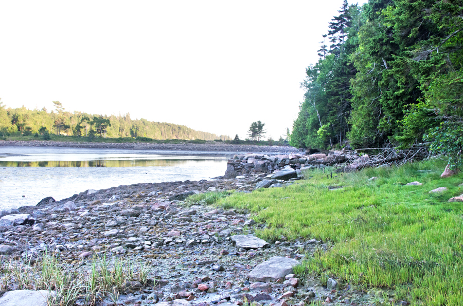
Otter Creek is a small town, true. I couldn’t find any official population figures, but there can’t be more than a couple of hundred people living there. Driving along Route 3 you see clusters of houses, a general store, a restaurant, an inn, a playground – you can tell it’s a community. Driving along the Park Loop Road, though, this is the view from the Otter Cove causeway, looking north toward Route 3:

So where’s the town? Until I started going through property maps for the Coast Walk, I hadn’t even realized Otter Creek is right there. The town landing, such as it is, is just past the end of that dark hill of spruce to the left. Grover Ave, one of the most populated roads in the town, is only a few hundred feet from the cove, off to the left somewhere back there. I started thinking of it as the Invisible Town, and found it bewildering that a population center on a Maine island had no waterfront. None. No wharf, no abandoned cannery, no saltwater farms, no old boatbuilding sheds, not even a visible boat ramp. (I went looking for the public boat launch and couldn’t find it. I think you have to walk down to it from the road, which would seriously limit its usefulness.) If you’re at all familiar with coastal Maine towns, this is kind of shocking. Impossible, even. Otter Creek is an old town by American standards – European settlements here date to the 1600s, a time when most transportation was over water because the land was impassable. Granted, Otter Creek doesn’t seem to ever have had a lot of waterfront development; this is the town around 1850, with only a few buildings visible at the shore:

from “The Artist’s Mount Desert” by John Wilmerding
There didn’t seem to be much information on the town at the local historical society; the village of Otter Creek is officially split between the towns of Bar Harbor and Mount Desert, so it seems to fall into the cracks. (It could also be that I haven’t adequately explored the historical societies.) Eventually someone pointed me toward The Waterfront of Otter Creek: A Community History, by Dr. Douglas Deur (2012) [https://irma.nps.gov/DataStore/Reference/Profile/2192442], a 244-page ethnographic report commissioned by the National Park Service. It’s absolutely fascinating, packed with stories and photos, and I highly recommend it, especially as I just don’t have space to get into a lot of the town’s history here, like why it is so oddly divided and the effect that has had on its social and geographical development. The whole thing is online and downloadable, just click on the title.

One of the first things I learned is that although the cove looks wide open, there are shallows and ledges across most of the opening, making a bit of a maze to get a boat through:

Second, the cove is exposed to the prevailing storm winds, so boats, docks, piers, and other wooden structures were regularly destroyed by storm surges. A number of bridges pre-dated the existing (stone and earth) causeway; all were washed out during storms.

Photo from Deur, The Waterfront of Otter Creek, 2012
Third, the shore is very steep, making access difficult. Many fishermen had fish shacks along the shore of the outer cove, which gave them a place to beach their boats, store bait, mend traps, and so forth, without hauling gear up and down the steep hill to town. (More about the fish houses later.) All of which explains why the town stayed small and the shore minimally developed. It sounds like a tough place to make a living from the sea.

Photo courtesy of Cynthia Lawry.

Photo courtesy of Cynthia Lawry
As to what happened to the town’s waterfront, it appears to have fallen to a conjunction of two early-20th-century phenomena: The Great Depression and John D. Rockefeller, Jr. Rockefeller had a vision for Acadia National Park and as we saw over at the Fabbri Memorial, it was a vision of wilderness. As the farmers and fishermen of Otter Creek felt the increasing pinch of the Depression, he slowly bought up the waterfront land of Otter Creek, removing the structures and allowing the shore to naturalize. [He also imagined an enormous salt water swimming pool in the inner cove, but nothing seems to have been done on that project.] According to Dr. Deur’s research, there were oral agreements with the fishermen that allowed them to continue using the fish houses in the outer cove, but once Rockefeller deeded the land over to the park, there was no record of those agreements. Since the fish houses were rough, messy, utilitarian structures, and the park’s mandate was to preserve the natural appearance of the landscape, this led to years of conflict between the fishermen and the park. The commissioning of Dr. Deur’s report appeared to me to be the Park’s response to flare-ups of that conflict in the 1990s, so I went to see Rebecca Cole-Will, Cultural Resources Program Manager for Acadia National Park to see what the park’s current thinking is on cultural vs. natural resources.

Photo from Deur, The Waterfront of Otter Creek, 2012
Jennifer (me): I’ve been curious about the Park and how you guys manage all the different resources. Kate Petrie recommended I talk to you ages ago, and I’ve gotten to Otter Creek, and thought this would be a really good time. As I said in my email I gather that Otter Creek has a been a bit of a controversial…
Becky: Well it has some management issues that are … not unusual … where history and traditional connections have kind of cross cut with traditional management of natural resource issues in the park, yes. I don’t know if you read Doug Deur’s report on Otter Creek?
J: Yes. Did you feel like that was a useful report for the Park?
B: Oh, absolutely! It was sort of documented recognition of traditional associations of the place that we weren’t aware of. That this was a place that has long, long connections … There are many of those places in the park; we oftentimes don’t get the opportunity to talk to the right people to give us that sort of context for the history of place. So it was, you know, as an anthropologist myself, it was sort of a ‘duh’ moment: well of course this place has really strong ties, and it’s unusual because of the history of the way the Park was created and encircled Otter Creek … I think the report [gave] us the opportunity to really understand how decisions about park management in the past hadn’t necessarily incorporated that local voice, and so gave us the chance to think about ways to re-set that relationship, to go out and actively engage with community. Which is … what parks should do anyway, but sometimes its easy to get busy with the day-to-day stuff and not do as much of that public communication outreach.
J: Well, what I originally wanted to talk to you about, even before I found out all about Otter Creek, was, I wondered how you choose, how you define resources and how you choose how to make them accessible and how to interpret them. One other place that I noticed was the Fabbri Memorial, where, you know, I can understand what was going on back in the 30s, I mean, military complex, why not erase it and naturalize the landscape? Which makes perfect sense except now, 70 years later or whatever, we’re all curious about what was there, now that it’s all gone and nobody knows about it. So how do you choose what’s important?

Photo from Deur, The Waterfront of Otter Creek, 2012
B: [laughs] That is a really complex issue, certainly, and … it goes back to the purpose of a park, … the originating mission for a particular park. All parks are charged with protecting the resources of the park unimpaired for future generations… That’s the statement that we all hew to in terms of the reason that the park service came into being; to protect these special places that were set aside for all Americans, that notion of the extreme democracy of parks. But, the irony of that is that in the creation of a lot of these places as open and belonging to the people, some people were excluded in the very nature of that creation, some indigenous peoples … for example. So the history of that goes back to the 19th century history of expansionism and the creation of the country and the notions of ‘what is America.’ Ultimately democratic, but ironically not necessarily so. … Acadia is very unique in that it was created wholly by donated lands. It’s a very unusual situation for a natural park. Most parks are big square blocks that were created as federal entities. Acadia wasn’t, Acadia was created by the work of a lot of individuals who acquired and donated land to create the park. So the mission and the purpose of Acadia really strongly hew to the vision of those 19th century conservationists. To set aside land to protect it and to preserve its pristine-ness, if you will. So in many ways Acadia’s always … been managed as a natural park, as opposed to a cultural park or a history park…. But that’s not to say that we don’t have cultural resources, and we’re recognizing those. But, a place like Otter Creek, it was acquired by Rockefeller with one thing in mind, he wanted to build his road through that area, so … the decision [was to] manage that for the natural resource value, [and] there wasn’t the recognition that this was traditional fishing territory…. So the park managed by removing the fish shacks, … to manage it for … natural resource values. Park management changes over time, and … we form our decisions based on what we know, and for managing of resources a lot of that has to do with the current state of understanding, based on documentation … like ethnographic resources, for cultural resources, for vegetation, and water quality, and so on. And we try to apply the best available science to the decision-making process, guided by law and policy…
J: …I [did an internship] with Charles Birnbaum twenty years ago when he was getting the Cultural Landscape Inventory started. Do you feel like cultural landscape is becoming more integral to the Park Service, or is that still kind of nebulous?
B: No, I don’t think it’s nebulous at all. I think that if anything it is becoming more of the notion that really all parks are cultural landscapes. They are created places that were created totally based on cultural values. That’s what a cultural landscape is.
J: The minute you set that park aside
B: The minute you set it aside, and you identify it as being something different or something special, you’ve already created a cultural context and it’s a created place; parks are managed for those created values, and also to provide for that visitor experience…, whether it’s wilderness values, or it’s opportunities for solitude, or the kind of recreational experiences we have at Acadia, but they’re all created situations and contexts. … Even in the places that are managed for wilderness … they’re places that have human value and human connection and the very concept of wilderness is very much a cultural value. There’s nothing ‘real’ about wilderness, it’s what we think it is. [There’s] the bigger level of the … interconnectedness of all of the resources and the values for which we have to manage a park. Every day you have to make decisions based on how … managing for this visitor experience [is] going to affect a resource, how is protecting this resource going to impact infrastructure, how do we interconnect and balance all of those; and every day we have to make some of those value judgements, again, guided by law and policy and what we understand for baseline documentation of the resources. So we spend a lot of time in resource management doing things like base-line inventories, monitoring air quality, water quality, monitoring for visitor impacts to resources, going out and asking visitors ‘what kind of experience did you have, what kind of an experience are you looking for?’ And then bringing all those pieces of data together … to shine a light on the decision-making process. We make decisions based on what we know, we don’t make decisions that are arbitrary or not grounded in good planning; there’s a lot of legislation and law that we bring to the planning process. Things like … the National Environmental Protection Act, which mandates that we protect the natural environment but also the human environment as well. And NEPA’s really a policy for planning. In terms of guiding good decision-making, and being able to justify what kind of decisions we make for major undertakings, and then the counterbalance to NEPA is the National Historic Preservation Act, which is another law that requires us to look at the impact of our undertakings on cultural resources or historic properties, and list properties to the National Register of Historic Places, and when we do work on them that we do it within the guidelines of rehabilitation, for example. So those are two … big pillars for planning, for understanding, and then the third one would be impacts and understandings about our visitors, because after all, we’re … providing for a high-quality visitor experience as well. … I think it always comes back to we earnestly try to make good decisions based on the information at hand, and so we have a thorough process of vetting … that does require public engagement. We need to go out and talk to people, find out what they’re thinking.

Photo from Deur, The Waterfront of Otter Creek, 2012
J: I’ve been working on this project since January, and it just happened to coincide that as the weather warmed up I got into the more public areas of the park. I think I hit Great Head in May, and so I started to see more and more people. I was alone for months! And I’ve seen people rock-climbing, people hiking, high-schoolers goofing off on the beach, I stumbled across a wedding, and I’ve been down there now with a COA professor doing scientific assessement of tidepools, and I was just blown away at how the heck do you manage all this; and that was just from Great Head to Otter Cliffs. How do you manage that kind of pressure, like balancing the wedding party with the rock climbers? That’s a hell of a job you’ve got!
B: Yeah, it sure is! It’s not easy. Again, … providing for the public to be able to do the things they want to in a park without necessarily either impinging on someone else’s experience or not being safe or damaging resources is a very delicate balancing act. And it’s tough. With something like those two events, they’re both regulated. Sometimes people get really frustrated with the amount of regulation that we require, but that wedding requires a special use permit, the rock-climbing, there’s a whole climbing-management plan in the Park and those climbers require a permit…, so it is tough, it’s very complicated, and I think people don’t realize that it’s like running a city when you try to run a park, and with a fairly small staff. The folks that are out there every day, the rangers and the interpreters and the visitor-use people really do a fantastic job.
J: Yeah! … [So] I reached Otter Creek and I found all these levels of history packed into this one tiny area
B: Definitely.
J: And then I came across the Fabbri archaeological report and the Otter Creek report, and by the time read the two of those my head was just spinning. It’s a lot of history!
B: There’s a lot of layers of history in this small space. We forget how small and for how long and how many layers there are. It’s a real palimpsest.
J: I just wondered, going forward, do you have plans to work with those documents, or are you ready to talk about that yet?
B: Work with them?
J: Do you have any plans based on the information?
B: Well at Otter Creek a big thing that we’re doing is we’ve really tried to re-engage with that community, to have meetings to try to understand; unfortunately the past is, and we can’t bring back the fish shacks, and we can’t, probably we won’t be removing the Otter Creek causeway, but are there opportunities for recognizing and providing for ongoing access into the Creek for the community, and those are some of the things we’re certainly trying to work on. Also just recognizing that that history exists; for example, last summer one of the interpretive programs at Blackwoods was about the history of Otter Creek. We’d never done that before. We could talk about this long history of the connection of this community to this place, and provide for that place-based understanding and experience for visitors that we never did in the past, so hopefully there’s that level of at least appreciating that history does exist even if it’s not necessarily visible on the landscape any more. So those are the kinds of things that we can do. There’s a new wayside that’s up at Fabbri …, maybe it hasn’t been installed yet, but it would be one of the outdoor display exhibits – if you’re at the memorial, then there’s this parking lot that looks out over the cove. … When you’re standing there you’ll be looking out towards the causeway and the Creek … and there’s information on that that talks about the history.
J: Oh cool, I’ll have to go take a look! I came through there in early May
B: So it might not have been installed yet.
J: I’ll have to go back.
B: So that’s at least one thing.
J: Yeah but that’s a big thing. It’s amazing the difference something as simple as a sign showing ‘what was’ compared to ‘waht is’ – that can be really valuable.
B: And there’s a trail that goes from Blackwoods, I don’t know if you’ve hiked the old quarry road?
J: I haven’t. I’ve heard it’s fantastic.
B: It’s a very nice trail, and that goes from Blackwoods around and eventually gets to the causeway, and it goes along the old Quarry Road, and we kept that name intentionally because … folks from Otter Creek said, ‘Let’s call it that;’ that’s what the history’s about. So that’s another opportunity. I know that some of the rangers do a hike that interprets the area. So there are things like that that we can do to recognize that there are those real deep layers of history and its all very much interplayed there.

Photo from Deur, The Waterfront of Otter Creek, 2012
J: As I continue hiking are there other sort of hotspots like this that I should look out for?
B: I’m trying to think where you’re going to be going next.
J: Well I’ve physically hiked as far as Hunters Beach, but in the blog I’m only up to Otter Creek. It takes a long time write these posts!
B: Yeah! … You know Stanley Brook is really kind of interesting because the road’s part of the historic motor road there, and … if you walk and look at Stanley Brook you’ll see all kinds of little features, little waterfalls and eddies and so on, and that’s a wholly reconstructed waterway there. It was probably built when Rockefeller with his engineers planned that road, they basically re-routed a lot of the stream so the road goes back and forth across it with the little bridges and so on. That’s a fundamentally altered landscape there.
J: That’s a different way to look at it. Do you know if Beatrix Farrand had anything to do with that?
B: She did, a little bit. If you go to the bridge, the carriage road bridge that crosses over Stanley Brook, that’s one of the most iconic bridges, it’s got the two side arches and then the center and the stream flows through one of them, you’ll see that you can still see remnants of her designed landscape there. There are some ash trees that are on either side of the bridge, and there’s a little bit left of that designed landscape from a long time ago there. So that’s a very cool place.
J: I’ll have to take a closer look. I’ve never actually walked through there, I’ve biked. The reason I asked about the stream is because at Dumbarton Oaks, are you familiar with it?
B: nods
J: There’s the Dumbarton Oaks Park, which is no longer really part of the managed landscape, althoughI shouldn’t say that, I was involved with this like 20 years ago so, but she had actually designed that stream, like where she had designed the waterfalls, she’d tuned them to a certain pitch, and I was wondering if she’d done something similar here.
B: Well I don’t know if she was involved with the design work for the stream or not. We don’t have a lot of records, most of it is anecdotal where supposedly she rode around with Rockefeller and said ‘Oh we should put a tree there,’ without having a lot of formal designs for her work. The person to ask would be Scott Koniecko. He’s the president of the Beatrix Farrand Society, Garland Farm. …What designed drawings exist for her work are all at Berkeley, and [Scott’s] gone and looked at them, so when I have a question about Farrand, I usually ask Scott. He can often answer that.
J: Alright, I’ll see what he can tell me!
B: But that’s an interesting question. It’s definitely a designed landscape, that entire stream, even though the average person wouldn’t recognize that as they’re driving up Stanley Brook Road, because it’s small and winding.
J: Well I’m glad you told me, I’ll definitely detour up when I hit the beach there. And are there any other hot spots? I’m walking the whole island, so eventually I will get everywhere. On the coast that is.
B: Wow, holy cow!
J: Yeah, it’s going to take so long.
B: I think one of the most amazing places is Wonderland. Without a doubt. I don’t know a lot about the history there but I understand it was either a little zoo or some kind of entertainment – it was called Wonderland for that reason – but if you go there now you’ll see that it’s one of the most amazing natural vegetation zones; it’s a globally rare community that includes the pitch pines and the broom crowberry there together, and it’s really amazing.
J: Wow, how did I manage to miss that all these years? I mean, I’ve been around Ship Harbor …
B: Wonderland is worth a visit for the vegetation there. We had a crew that, well there was a team of dendroecologists that did some dendro work coring trees in the park just within the last month, and there are 300 year old pitch pines at Wonderland. They’re just tiny, tiny, little trees, because they’re kind of like these bonsai… The inventory and monitoring network folks have done a wonderful briefing that talks about management decisions for protecting Wonderland based on an understanding of the globally rare nature of the vegetation there.
J: I’ve been really impressed at how much is online. I mean I found both the Otter Creek and the Fabbri archaeological, all of that I found online.
B: You know about IRMA?
J: No.
B: IRMA stands for the Integrated Resouce Management Application. If you search on that there’s a lot of digital records of all kinds of stuff related to the Park.
J: Awesome!
We chatted a little more, and I took my leave, wondering a bit how to incorporate our discussion into the narrative of the Coast Walk. As you can see, I’ve left it as a bit of a side trip into theory, and we’ll pick up back on the shore in the next post, when Cynthia Lawry joins us to talk about her childhood in Otter Creek. I’ll leave you with this intriguing diagram from Deur’s report:

Photo from Deur, The Waterfront of Otter Creek, 2012
July 10, 2015
I went back to the Fabbri picnic area to see the new wayfinding signs. Nice!


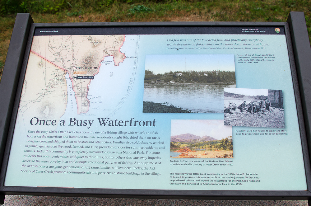

Geez, Schooner Head feels like decades ago!
From top to bottom, left to right: kelp holdfast, Dog Whelk (Nucella lapillus), driftwood, beach stone, acorns (possibly Quercus rubra), Old Man’s Beard lichen (Usnea sp.), balloon with ribbon, knot of polypropylene fishing rope, feather (probably Herring Gull), beach stones, kelp holdfast, Waved Whelk (Buccinum undatum)

May 20, 2015: 6:30am. 55 degrees, chilly, light breeze, sun and clouds. 9 Herring Gulls, 1 Crow, 1 Loon, 2 male Eider Ducks, 4 Black Scoters (2 male, 2 female), 3 Wild Turkeys (Meleagris gallopavo), 2 female Common Merganser (Mergus merganser), 2 Laughing Gulls (Leucophaeus atricilla), 1 Lesser Yellowlegs (Tringa flavipes) [although I’m not totally sure; it might have been a Solitary Sandpiper.]
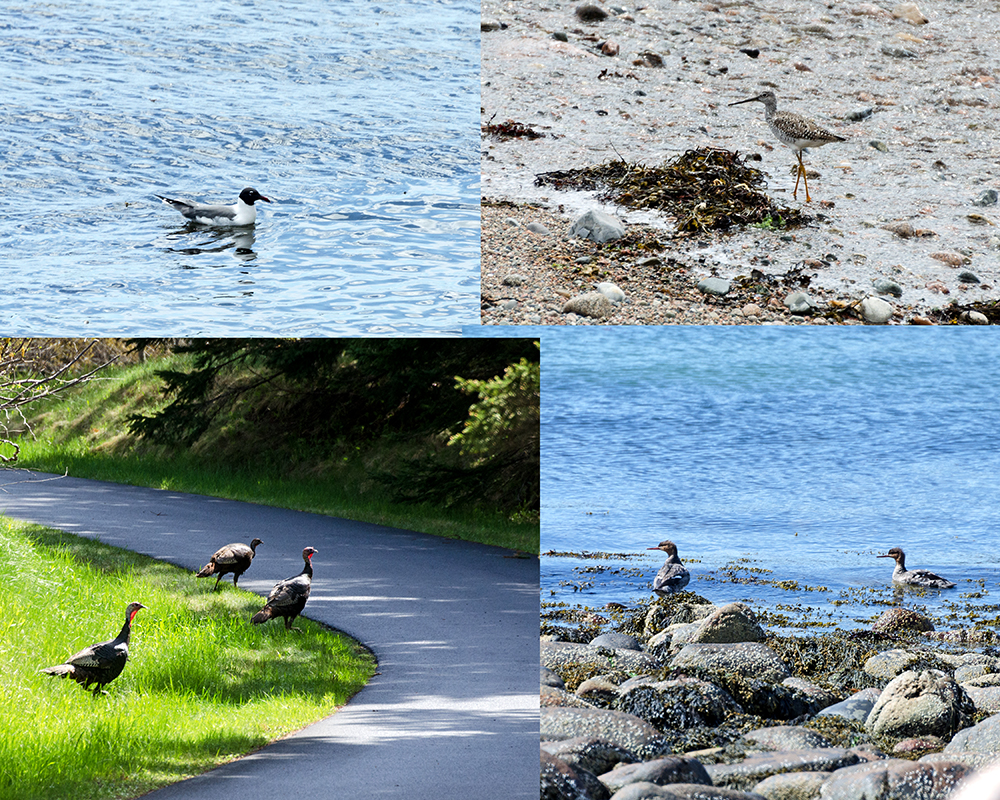
Clockwise from top left: Laughing Gull, Lesser Yellowlegs, Common Merganser, Wild Turkey.
I walked down the Fish House Road awfully early on a bright, cool morning in late May, and headed south along the shore of Otter Cove.
The terrain underfoot changed quickly from gravelly pink granite to small boulders so covered in periwinkles it was hard to know where to step, to similarly-sized boulders completely covered in rockweed. It was slow, wobbly going over the rockweed.

My side of the cove was still in shadow, and I watched the west side gradually get brighter as the sun rose higher in the sky.

The fish house across the way looked tiny against the hill. (We’ll be visiting it soon!)
I stumbled across an enormous tide pool, shallow now at dead low tide. The morning light hit it at an angle, lighting up the interior like an aquarium. Notice that there’s a sandy-looking bottom, very exotic around here.
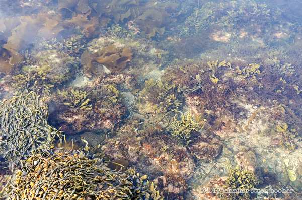
Because it was so shallow and perfectly lit, I was able to get some great photos with minimal distortion. I think these little tube worms are Spirorbis borealis.
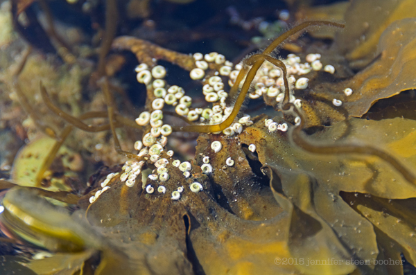
I tried to get a shot showing the worms feeding, but they were harder to photograph than barnacles! If you look closely, you can just make out the feathery arms of one at the top right, and another like a little star at bottom left:

The Coralline and its crustose cousin were wearing matching shades of pink:

There are three Slipper Shells piled on top of one another here:

OK, this was new. A periwinkle had rolled over, and had to pull itself upright. I always wondered how they would do that – turns out they can come a long way out of the shell, then suction on to the nearest solid surface and just pull themselves over. This one must have had half its body-length out of the shell by the time it found something to hold onto. I didn’t get a photo of that, I was too fascinated watching. But I did notice those little orangy-green clusters near the eyestalks. I spent some time hunting down diagrams of periwinkle anatomy and parasites online but couldn’t figure out what those are.


A closer look at that “sandy” bottom shows it’s actually finely crushed shells:


This is probably the native Sea Cauliflower (Leathesia marina), but it might possibly be Colpomenia peregrina, a newcomer to the area. They look like little olive-green balloons:


The day warmed up a bit as the sun rose higher over the hills, and I came to an outcrop of pink granite that blocked my way.

Climbing up, I found a decaying stairway and realized I must be below the Fabbri Memorial.

I’ve known the area for years as a picnic spot with convenient bathrooms, and never paid much attention to the memorial itself, which is the standard rock-with-a-plaque: pretty boring, even if you take the time to read the tiny text.

I felt sort of obliged to at least find a photo of Fabbri for this blog, and stumbled across several resources that made me look not only at the memorial but at the whole of Otter Cove with fresh eyes. [Specifically: The Fabulous Radio NBD, Brandon Wentworth, 1990; Archaeological Investigations at Fabbri Memorial, Diane Lee Rhodes, Denver, Colorado, National Park Service, 1985; this wikipedia entry about the radio station, Karen Zimmerman’s essay about the lookout tower, and Fabbri’s obituary in the New York Times.]
It looks so wild and untouched here, except for the causeway, but standing at the memorial, to your right the town of Otter Creek is just beyond the trees at the head of the cove, the forest across the cove screens busy Blackwoods Campground, and somewhere close by was once a submarine refueling station with a substantial steel pier. You would be standing in front of the main administration building of the “radio station” mentioned in the plaque, which was a large naval communications station that included barracks, medical offices, at least 5 radio receiving stations, two 185′ tall steel antennae, that at its peak during World War I employed about 100 men. All of that is either deliberately hidden or has been equally deliberately wiped away. My mind did the usual bit of boggling, and I started to understand just how directly and actively the conservationist philosophy guiding the establishment of the National Parks had affected this landscape right here. It was one thing to wander around the ruins of George B. Dorr’s estate in Compass Harbor – the presence of the ruins and the access roads signal that this was once an inhabited landscape that has been allowed to naturalize. Otter Creek, Fabbri’s radio station, and the campground are invisible, as if the cove is pretending to be wilderness. Which it is, because there are trends in conservation and in historic preservation, and until recently, wilderness was more highly valued than vernacular history. For many people it still is.
Confession: I’m a landscape architect with training in historic preservation, so I appreciate a pretty view, a functional native ecosystem, and a cultural landscape. As you can tell from any entry in this blog, I thoroughly enjoy the traces of history. Whether they are left as mysterious ruins, as at Dorr’s estate, or whether they are explicitly interpreted, as in the excellent “Museum in the Streets” program that has finally reached Bar Harbor, I find they add enormously to a sense of place. I understand why the old radio station was erased – in the 30s it was so recent it wasn’t considered history yet, and the prevailing philosophy was the preservation of natural beauty. Why not remove all trace of a utilitarian military complex?
I’ve got a meeting scheduled with the Chief of Resource Management at the park next week, and am really looking forward to learning about current park management philosophy, and how on earth they find a balance – any given stretch of coastline might be a resource for fishermen, historians, rock-climbers, botanists, geologists, artists, or plain old tourists, so how do you decide what access to provide and what information to present? But let’s turn our attention back to the memorial.

photo from Rhodes, Diane Lee, Archaeological Investigations at Fabbri Memorial, Denver, Colorado, National Park Service, 1985.
Alessandro Fabbri was the son of one of the ‘Morgan Men’ (partners in J.P. Morgan’s company) who were a large part of Bar Harbor’s summer colony around the turn of the 19th century. Although he was born in New York City, he spent most of his childhood in Italy. Fabbri’s home in Bar Harbor was an Italianate villa called ‘Buonriposo’ on Eden Street. [It was demolished in 1963, and in a year or two when we Coast Walk that area we’ll visit whatever’s left of it.] Around 1912 he developed an interest in radio transmission, and with help from Ralph Tabbut of Bar Harbor built a wireless station here. When the US declared war on Germany in April of 1917, Fabbri donated his yacht to the US Navy, and offered to donate the wireless station as well if he could be named station manager, as he didn’t want it manned by novices. The Navy refused on the grounds that civilians could not manage a military station, so Fabbri became an ensign in the Naval Reserve and after searching for a site with good potential reception for European radio signals, he leased a property known as ‘Otter’s Nest’ which was located where the memorial is now.
photo from The Fabulous Radio NBD, Brandon Wentworth, 1990
Otter’s Nest had been the property of the Palmer family of Washington, D.C. Purchased in 1883 by Aulick Palmer, in 1910 it became the “Country Club of Mount Desert.” Members included John D. Rockefeller, George Dorr, and Robert Abbe. The club was successful for a time, but closed by 1917. The archaeological report I mentioned includes a few intriguing bits of early history: it cites a prior survey listing a “contact period Indian settlement in the vicinity of Otter Creek Point,” and a 1688 census listing one Indian family living on the east side of the cove (p.20), mentions that Samuel Champlain may have anchored in the cove, and includes a history of the land ownership (p.21-22). (It’s a really interesting and very thorough document, 214 pages including illustrations and maps, and it is online here, if you’d like to read the whole thing.)
Station Commissioning Ceremony. (photo from Rhodes, Diane Lee, Archaeological Investigations at Fabbri Memorial, Denver, Colorado, National Park Service, 1985.)
In addition to the Otter’s Nest property, Fabbri leased a 5-acre tract to the north, providing 12 acres total for the Otter Cliffs Radio Station, which was officially commissioned in August of 1917. The Otter’s Nest cottage became the receiving station and quarters for the radio operators. The station had outstanding reception capabilities and by 1918 it was the “pre-eminent receiving station in the US of over-seas transmissions.” (Rhodes, p.32) This was the radio station the Germans contacted to initiate peace overtures in 1918, and the station that received the declaration of Armistice.

photo from The Fabulous Radio NBD, Brandon Wentworth, 1990
Other buildings were constructed – barracks, medical facilities, mess hall, etc –

photo from Rhodes, Diane Lee, Archaeological Investigations at Fabbri Memorial, Denver, Colorado, National Park Service, 1985.
and in 1918 the whole point was made a secure area by the Navy, in part due to fear of submarine attacks. An electric fence sealed off the point:

photo from Rhodes, Diane Lee, Archaeological Investigations at Fabbri Memorial, Denver, Colorado, National Park Service, 1985.
To increase the station’s capabilities, the Navy built a remote transmitter site at Seawall, linked to the Otter Cliffs station by a submarine cable. [We’ll visit the site when the Coast Walk reaches Seawall.]

photo from Rhodes, Diane Lee, Archaeological Investigations at Fabbri Memorial, Denver, Colorado, National Park Service, 1985.
Fabbri resigned in 1919 after the war’s end, and was awarded the Navy Cross in 1920. He developed pneumonia after catching cold on a duck-hunting trip in 1922, and died three days later. He was only 44.

After the war’s end, the station’s workload fell off sharply and by 1920 there were only about 60 men stationed there. In 1929, Rockefeller announced plans for what would become the Park Loop Road, but it took several years to negotiate an agreement with the Navy. The process began in 1934. The station was dismantled and all the buildings were razed by 1935. Rockefeller had the radio compass facility moved over to National Park Service land at Schoodic. The Loop Road was built shortly after, and runs between what used to be Otter’s Nest and Barracks A. The Fabbri Memorial rock was dedicated in 1939.
The archaeology report mapped the foundations, dump sites, sewer pipes, and stone-lined wells they found, and has photos of lots of refuse including early 19th century china shards as well as electrical wire, batteries, and other debris from the radio station. The report recommended the park develop interpretive displays – “We have many areas in the NPS system that illustrate and commemorate the Revolutionary and Civil Wars, but very few representative examples of World War I activities, especially communication technology. Acadia’s Fabbri area is a unique and eloquent tribute to the technology and military defenses of the period, and the to dedicated men who served here.” Still a cool idea, if you ask me.

After all that research on the radio station, I think I’ll hold off on the Otter Creek history until next post. All of that came later, anyway. After I noticed the stairs leading up the bluffs, I turned back to the pools on top of the ledges. I’ve been looking at them even more carefully since finding the salamander eggs, and today I noticed little black swimmy things (top) that looked like slimy commas when I caught them (bottom.) After some research, I think these are mosquito pupae. Oh joy. There was an adult stalking me, too:

Then there were these odd little things:

They were so small I couldn’t see any detail on them, and too far down to use my iPhone macro lens on. They looked like tiny seeds, but they were swimming. (That black stuff is dead leaves at the bottom of the pool.) I hunted around among ephemeral pool references, and I think they must be something like a clam shrimp or a seed shrimp:

Seed shrimp (from E Ray Lankester (A Treatise of zoology) [Public domain], via Wikimedia Commons)

Eventually I reached a point where I could go no further along the ledge, and couldn’t climb down. I didn’t much want to climb up the bluff, so I retraced my steps.

Picking my way back through the rockweed, I almost missed this:

Can you see it? How about now:

We’ve got a Common Sea Star (Asterias rubens) and a Sea Cucumber (Cucumaria frondosa). The Sea Cucumber is particularly cool; they are deep water animals and I never expected to find one in a tide pool!
Aren’t the colors amazing?


This particular wildlife took advantage of me being precariously balanced and holding an expensive camera over a tide pool to bite me on the wrist:
My first black fly (Simulium sp.) bite of the season. Probably not the last!
Next week: cod, granite, lobster, and a National Park: the history of Otter Creek and why you can’t see the town from the water.
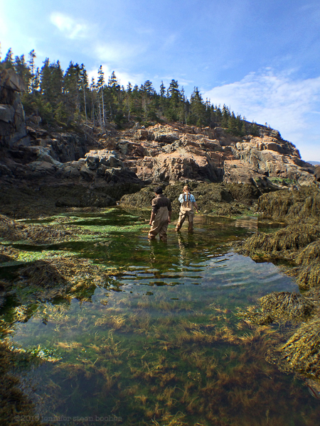
May 16, 2015: 3-4:45pm, 59ºF, had been overcast all morning but the sun came out just as we started to hike down. Very warm in the sun and out of the wind. Stayed sunny until we finished, then started to rain lightly when I went off on my own. 4 eiders (2 male, 2 female), 1 loon, 1 guillemot, 1 herring gull eating a very large crab (couldn’t see what kind), 2 nudibranchs (Aeolidia?), 1 sea urchin (Strongylocentrotus droebachiensis).


Left: Rose Dawson. Right: Chris Petersen
Walkers: Dr. Chris Petersen, Professor of Biology, College of the Atlantic; Rose Dawson, Amelia Gan, Devina, and Kanishka Suwal, students at COA, Syracuse, Duke, and Bucknell.

Left to Right: Kanishka, Devina, and Amelia
This was a bit of a bonus day – Chris invited me to join a field trip he had planned with his students as part of a long-term project. In the 1920s, Duncan Johnson and Alexander Skutch, visiting scientists at the MDI Biological Laboratory, spent several years making a very detailed analysis of vegetation in a large tide pool on Otter Point. They published their findings in Ecology magazine in 1928, accompanied by a number of black-and-white photos of the tide pool. [In a typical Coast-Walk-research wild goose chase, in the 1928 article the authors mention that the Bio Lab had a facility nearby called the Ogden Station, which sent me poking through Library of Congress maps and histories of the Bio Lab to figure out where on Otter Point that might have been. Nope, still no idea, although I did gather that it was only there for a few years.] Since the fall of 2013, Chris has been working with his students to re-inventory the tide pool with an eye toward determining whether there has been a change in the species or distribution of marine algae there, and if so, what might have caused it. [The term ‘marine alga’ is pretty much synonymous with what the rest of us call ‘seaweed,’ although it includes stuff like crustose coralline that most people don’t realize is a plant. Since I’m a groupie, not a marine biologist, I tend to use ‘marine algae’ when I want to be comprehensive and ‘seaweed’ when I don’t want to sound pompous.]
The students were able to use the old photos to identify the tide pool, which I found pretty impressive, given that they were working from shots like this (same area at high and low tide):
Johnson and Skutch, “Littoral Vegetation on a Headland of Mt. Desert Island, Maine,” Ecology, Vol.9, no.2, April 1928, p.213.
In their preliminary report from 2014, students concluded that the number of species had dropped from 46 in 1928 to 24 in 2014. They also noted that 12 of the 2014 species had not been identified in the 1928 report. It will be very interesting to see how those numbers change with the seasons and over the course of several years.
Jumping back to the present day (a lovely spring afternoon), I met Chris and the others near the Otter Point parking lot, where we hiked down to the study area:
Everyone else got straight to work, climbing into waders and gathering samples while I hovered on the rocks above, asking questions and trying not to get in the way. I’ve mentioned before that identifying seaweeds often stumps me, and it made me feel slightly better to learn that several of the seaweed species couldn’t be confidently identified without a microscope.


Chris was able to help me distinguish between Rough Periwinkles (Littorina saxatilis) and Common Periwinkles (Littorina littorea), something I’ve been trying to figure out for years. Rough periwinkles are tiny, and look a bit like a Northern Lacuna (Lacuna vincta, which I saw for the first time back at Schooner Head) but live higher up in the littoral zone – the lacuna stay deeper, which is why I’d never noticed them before.
So if I’ve got this right, this is a Rough Periwinkle:
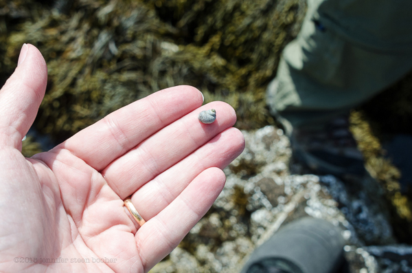
and these are Common Periwinkles:

and this is a Northern Lacuna:
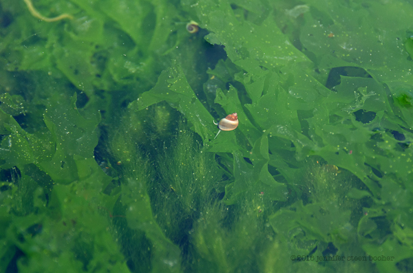
Cool, I think I’ve got it! And as a bonus, Rose found Lacuna eggs in the tide pool (those are my fingerprints in the background for scale):
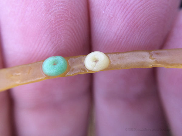
Chris pointed out that the green algae (like the stuff Kelley and I called ‘Elvis Velvet’) are growing right now, but the periwinkle are eating them, moving outward from cracks in the stones, so all those bright green areas will disappear in a month or two, and later in the season red algae will dominate the rocks:

Just then a seagull pulled an enormous crab out of the water, which put up quite a fight, and I got distracted wondering which of them would win:

The seagull won. And then the wonders started coming thick and fast. There was a limpet on a piece of seaweed, which it couldn’t cling to as effectively as a rock,

so I got to see the soft side of a limpet for the first time:
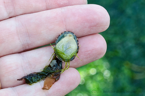
And then Rose found a Maned Nudibranch (Aeolidia papillosa?):


Even cooler than the little white one I found yesterday! Then we found a tiny sea urchin (Strongylocentrotus droebachiensis), decorating itself with a bit of kelp:


There were others hiding under a ledge, covering themselves with bits of rock and barnacle shells. Chris said no one knows why they do that, some people say it is camouflage, but others believe it is to shield themselves from the light.

After an hour or so, the group felt they’d done a fairly complete survey, and we headed back up the cliff. I thanked everyone for letting me join them, and continued on, determined to finally make it around the end of Otter Point. A thick bank of clouds had drifted up, and the temperature was dropping. As I walked over a relatively flat section of ledges just a little way off the path at the top of the cliff, I stopped short, peering into a brackish pool.

Salamander eggs at last! And so close to hatching I could feel them wriggling in my fingers. (I lifted this clutch up just long enough to snap a photo, then put it back gently and carefully.) I think these are Spotted Salamanders (Ambystoma maculatum).

While trying to identify the eggs I learned something new: the green color is from an alga, Oophila amblystomatis, that has a symbiotic relationship with the embryo. Apparently the jelly surrounding the eggs keeps them from drying out, but (according to Wikipedia) it also makes it hard for the embryos to get oxygen. The alga produces oxygen through photosynthesis, and also consumes carbon dioxide produced by the embryos. Even trippier, there’s evidence that the alga gets into the embryo’s cells as it develops so it gets passed from generation to generation. Mind boggled, again.
I couldn’t be sure, but it looked like some salamaders had already hatched:
 There are three swimmy-things in the upper part of that photo – the two outer ones are mosquito larvae, but I think the center one is a newly-hatched salamander.
 When I finally stood up again (having been squatting, lying down, and generally hovering over the salamander egg pools for at least half and hour), I stretched, shook myself, and realized I was looking across Otter Cove at Western Point, and when I turned, there was the cove itself. By now, though, the temperature had dropped almost ten degrees, and fat raindrops were splashing down around me. I scrambled a little farther across the ledges, hoping to make a least a little progress into the cove,
 but the ledges abruptly dropped off into a much more tumbled and slippery-looking landscape:

For a few minutes I stared at those rocks, tracing possible routes through the seaweed or up and down the ledges. There was no simple way down from the ledge I was on, so I walked along the road for a bit, looking for a passable descent. I’d already spent three days on Otter Point – longer than I had estimated it would take me to get all the way along the eastern shore of Otter Cove. I could feel the two years I’d allotted for this project stretching longer and longer, and the pressure building to get as far as possible on each walk. Then I sighed. The rain was getting more determined, the tide was on its way in, and I was already tired; the idea of wobbling and scrambling while getting drenched from above was decidedly unappealing. I headed back to the parking lot. There’s always tomorrow!
I’m giving three workshops in July – one outdoors in Acadia National Park, and two indoors at the Artwaves studio in Bar Harbor. If you’ve enjoyed seeing the Coast Walk still life photos, you might enjoy learning how to do similar work of your own. These are low-tech, never fear, we’ll be working with camera phones and white paper! You can sign up for the Artwaves workshops here: www.artwavesmdi.com The National Park program is free and doesn’t require sign-up.


And here is the still life for Coast Walk 6: High Seas to Schooner Head, January 19 – April 3, 2015. The still life photos skip from Coast Walk 3 to Coast Walk 6, because, as you may remember, from Compass Harbor to Schooner Head the Coast Walk was plodding through snowdrifts and confined by icy cliffs to the higher elevations, so there was no beachcombing until April. Just looking at this photo reminds me vividly of the spring thaw, the constant trickles of water from melting ice, and the moment I was finally able to shimmy down the rocks to the tide line.
Top to Bottom, Left to Right
Column 1: driftwood, weathered fiberglass, driftwood
Column 2: feather
Column 3: seaweed holdfast (probably Laminaria), plastic-coated wire, Irish Moss (Chondrus crispus), weathered fiberglass, Common Periwinkle (Littorina littorea)
Column 4: seaweed with holdfast (probably Laminaria again), Jonah Crab (Cancer borealis)
Column 5: beach stone, Fucus sp. attached to barnacle (Semibalanus balanoides), bird bone, Common Periwinkle
Column 6: driftwood, beach stones, seaweed (some kind of kelp) partially covered with bryozoan colony (I think it’s Membranipora membranacea.)
