

December 21, 12-2pm. 49 degrees, blustery and overcast with patches of sun. Sun glowing grey behind clouds, ice seeping out of some ledges.

Walkers: Brenda Beckett, PA-C, MDI Hospital, & Captain, Acadia Photo Safari; Howie Motenko, Software Engineer, Jackson Laboratory, & photography expedition leader, Acadia Photo Safari. Howie is also working on a long-term photography project called Painting Islands. Brenda first joined the Coast Walk in February 2105.

Seaside Hotel at left and Glencove hotel at right. Image from “Northeast and Seal Harbors, Mount Desert, Maine” souvenir photo booklet, courtesy of the Northeast Harbor Library.
The last Coast Walk ended at the Seal Harbor Town Dock, and since then I’ve done a ton of research on the area. If you haven’t seen it yet, I just published an ‘Addenda’ page with everything I learned about the eastern part of the harbor that I wish I’d found before the walk from Hunters Beach. Let’s start today’s walk with a a quick primer on Seal Harbor history (mostly from Revisiting Seal Harbor, bibliography at bottom of post) before we start on the Coast Walk proper:
• The first European settler was John Clement of Bucksport. Clement was a cooper and built a workshop on the beach in 1809 and a house on Ox Hill. The house burned in 1817, and the Clements rebuilt close to the beach.
•First ‘town’ area was at Bracy Cove in the 1860s. More about that when we get to Bracy Cove.

‘Seaside House,’ the Clement family boarding house. Photo from Vandenbergh and Shettleworth, Revisiting Seal Harbor
• In 1875 the Clement family quit coopering and fishing and remodeled their home as a boarding house for 10 boarders, calling it ‘Seaside House.’ They promoted Seal Harbor as less fashionable, slower paced and more rustic than Bar Harbor, and it gained a reputation as an intellectual resort. Scientists, artists, musicians, and writers gathered in the public rooms. The Clements were very successful, enlarged the inn several times, and eventually built a much larger, fancier place called the ‘Seaside Inn’ to distinguish it from the ‘Seaside House.’ You can see both here:

The Seaside Inn is at left, and the Seaside House is at right. No idea who the house in the middle belonged to. Photo courtesy of the Seal Harbor Library.
•In 1884 Captain Edwin Lynam and Robert Campbell opened the Glencove Hotel at the other end of the beach. This one was apparently even more appealing to the intelligentsia, and “the scholarly atmosphere was said to be such that bellboys often conversed with guests in Latin. ” (May, Johns Hopkins Magazine, 1995) On a side note, the article quoted is an essay on Thomas Eakins’ visit to Seal Harbor while painting a portrait of Dr. Henry Rowland, and has some great anecdotes about life in Seal Harbor in 1897. The full text is online – check it out.

Image from “Northeast and Seal Harbors, Mount Desert, Maine” souvenir photo booklet, courtesy of the Northeast Harbor Library

Detail of George N. Colby map, 1887, showing the location of the hotels and stores.

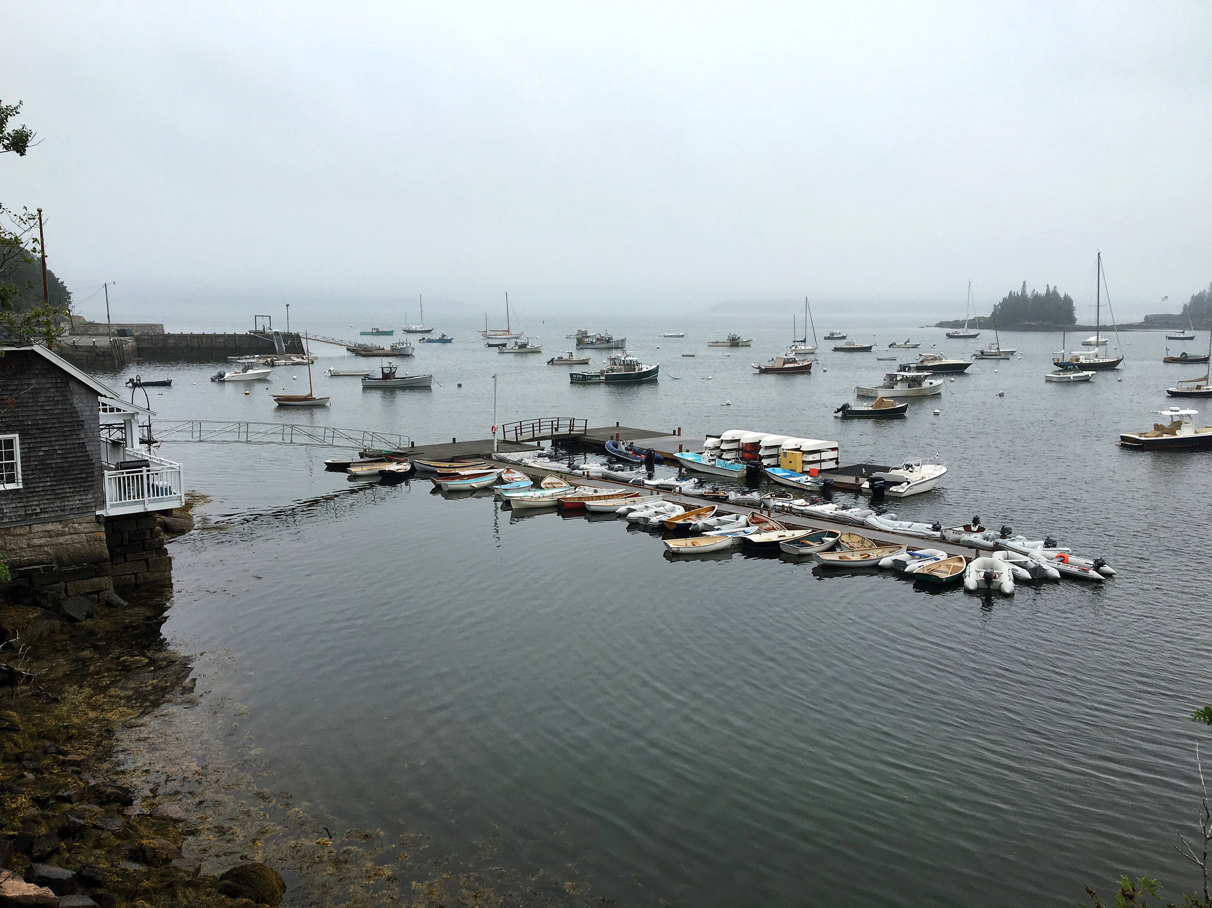
The town dock as it is now. I took this photo in August because I hadn’t gotten a good one on the December walk. I’m sorry about all the time-jumping. Pretend we’re in a TARDIS, ok?
Which brings us at last to the town dock, which was built in 1882 as a landing for the Eastern Steamship Company, which provided weekly service from Rockland on the Mount Desert.

I believe this is the ‘Mount Desert,’ which was a side-paddle steamer. Photo courtesy of the Seal Harbor Library.
In 1893, a group of businessmen, including George Cooksey, built the Golden Rod to run daily circuits between the Mount Desert Island resorts, and in 1903 the steamer J.T.Morse was brought into service and ran until 1933, when autos became the main form of transport to the island.

The J.T. Morse at the Seal Harbor dock sometime before 1920. Photo courtesy of the Seal Harbor Library.
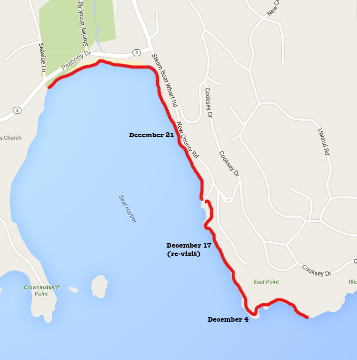
Unloading trunks and baggage circa 1905. Photo from Vandenbergh and Shettleworth, Revisiting Seal Harbor, 1997.
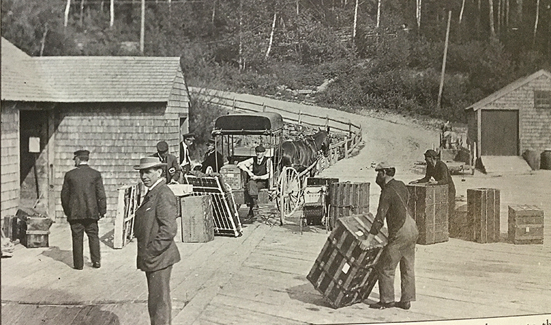
The Eastern Steamship wharf circa 1920. Photo courtesy of the Seal Harbor Library.
After the steamship era passed, the wharf became the Acadia Pier in the mid-1930s. It sounds something like the current Islesford Dock – a seafood restaurant and boating destination. The Acadia Pier was popular until WWII gas rationing killed a lot of tourism. It was dismantled in 1945, bought by the town at some point and rebuilt as the town dock.

Photo from Vandenbergh and Shettleworth, Revisiting Seal Harbor, 1997.

Photo from Vandenbergh and Shettleworth, Revisiting Seal Harbor, 1997.
OK, I’m exhausted and we haven’t even started the walk yet – let’s go!
Brenda, Howie and I met on a raw, blustery, overcast afternoon at that incredibly historic town dock, slid and scrambled over the wall and picked our way down the slope. The shore was covered with a thick mat of rockweed, so walking required enormous concentration and it was difficult to stay close enough to each other for my phone to pick up our conversation. The howling wind drowned out most of what the phone did catch, so I only have a few bits to share with you.

J: Looks like there’s been a lot of lobster feasting over here.
B: Why would somebody throw their cooked lobsters [on the shore]? … There’s a dumpster up there in the summer, and I bet some of the trash gets blown over here.
J: Or seagulls [carry it].

The horse trough was installed to celebrated Seal Harbor’s centennial in 1909. The seal head spigot was added the following year. Photo courtesy of the Seal Harbor Library.
I mentioned that I was looking for old photos of the harbor area, and it turns out that Howie had been helping scan and clean up old negatives for the library.
B: Yeah, Lance [Funderberk] gave him some old photos of Seal Harbor, historic photos. … It’s the public library, that’s who has the collection, and Howie was helping.
H: He gave me the digital negatives to try to improve them.
J: Sure. Is it the Northeast Harbor library that has them?
H: No
B: The Seal Harbor
J: Oh! Oh my gosh, I always forget there’s a library here!
B: Yeah, they have a whole collection. And it’s a really cool picture with these rocks … and don’t you see the yacht club also?
H: That might be a different picture.
Well, that short conversation led me into a whole maze of connections! First, I found the photos on the library website, but the website has very little information about where the photos came from, who took them, and who the people in them might be. Phone calls to the library weren’t helpful – the people I spoke to told me to talk to Lance Funderberk. So finally I emailed Lance, and we will get together sometime next month to chat about that. I also found out that Lance and his wife Anne are a great source of stories and history from Seal Harbor, so I’m really looking forward to talking with them!
The next step was to make up for having forgotten the Seal Harbor Library’s existence by visiting, and on August 16, I finally made it there.

The library was built in 1899 for $1000, on land donated by George Cooksey (him again) and Charles Clement, and was designed by William Partridge of New York.

Photo courtesy of the Seal Harbor Library.

Other than a small addition on the west side, it seems to be much the same.

The harbor is a lot busier in August than it was in December.

I could only get the whole library in by using a panorama photo, hence the distortion.

I spent a couple of happy hours in this room looking through books stamped “do not circulate,” and took several others home with me. I wish I could say that my high-school self would have been amazed at the amount of research I do now, but truth is I’ve always been a total geek. It’s hard to say which I enjoy more; climbing up granite ledges in the dead of winter, or unearthing the perfect photo in the bottom of a box in the archives.
Anyway, back to December’s Walk:

We squeezed past the foundations of the Yacht Club, which was built in 1912. The stone pilings are held in place on the bedrock ledges with steel pins:

Oops, time for more historic photos.
Photo courtesy of the Seal Harbor Library

Photo courtesy of the Seal Harbor Library

Photo courtesy of the Seal Harbor Library
My son taught sailing at the yacht club this past summer, and I drove him to work most mornings, so I got very familiar with this view:

And I was also able to photograph the rockweed-covered boulders we slid over at low tide back in December at high tide in August:

It’s a forest, isn’t it?
And back to December again:
Knowing that Brenda collects heart-shaped rocks, I pointed this one out to her:

J: Heart-shaped?
B: … Half a heart.
J: Half-hearted.
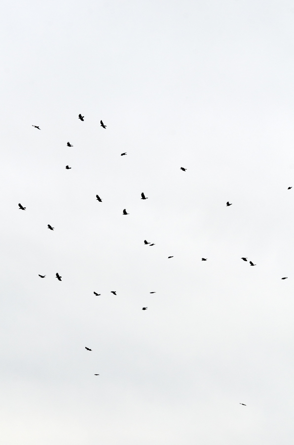
J: Wow, look at all the crows. Holy cow! I have NEVER seen so many. [Ed.note: I counted 56 crows in one of my photos.] Last week I saw a raven and two eagles down here.
B: There was an eagle’s nest at the point.
J: Must have been the same ones.
B: Sometimes we’d be getting ready to go on the Photo Safari and I’d see them. One time Howie was up on the dock and I was down in the boat, so I just texted him, ‘Eagle soaring overhead.’ So he was meeting a guy and he was like, ‘oh look up, take pictures!’
J: Oh that’s awesome. Happy customers, right?
We spotted puddles of old tar in the cracks of the ledge:

And noted the appearance of patches of sand among the boulders:

J: … Look how much more sand there is. It’s small rocks over sand. And it changes right at that dock.
B: We walked all the way out there one time when it was I think a full moon low tide, and it was sandy pretty much all the way.
J: So sand all the way out to the town dock?
B: Yeah. Because you can see there’s sand right out there.
J: Oh yeah.
B: I mean there were a few areas where we had to walk around a couple rocks.
J: Well the tide’s still on its way out.
And it’s time to go off on our next tangent, which is called ‘Why is there sand on the Seal Harbor Beach?’
Answer: Glaciers.

Photo from Braun, Geology of Mount Desert Island, 2016.
First off, the southern end of Jordan Pond is a glacial moraine. That’s an area where the front edge of the glacier paused for a while and dropped debris in a concentrated area. A moraine often acts as a dam for a pond, but at Jordan Pond the meltwater flowing under the glacier “cut a channel through the moraines and deposited a delta in the ocean.” (The Geology of Mt. Desert Island, 2016, p. 62.) Not the current ocean, because the land is about 200 feet higher now than it was at the time of the glacier – this ancient delta is farther north, closer to the pond. Below the sea-level elevation at the time of the glaciers (220 feet), the land was covered with marine mud. Sea level started dropping as the glacier retreated, about 16,500 years ago. “Stanley Brook from its headwaters to the beach is incised into thirty to forty feet of marine mud with a clayey silt texture. This material is quite weak and erodible, both by gullying by running water and slope failures … A distinct thirty- to forty-foot scarp in the marine mud … runs along the eastern side of the valley (lavender color in Figure B-18). The houses on the the western side of Route 3 sit on top of the scarp.” (p.129)

One drawback to photographing in summer is that the leaves hide the shape of the land. I hiked up along the brook, but never found a spot where I could photograph the scarp. In the panorama above, you can see a little of how steeply the land rises at the right. The edges of the brook look like this far up into the woods – undercut and eroding:
So the headwaters of the existing Stanley Brook cut through an ancient delta of sand and gravel deposits, and the rest of the brook is running through deposits of marine mud on the ancient sea floor. All of which means the brook is slowly moving all that ancient sand and gravel and mud downstream to the beach, and all of us playing in the sand on the beach are continuing a process that’s more than 20,000 years old.

Yup. And back to the Coast Walk again.

J: So I don’t think I’ve talked to you guys in ages. How was the boat this year?
H: The boat was very busy. Very busy, too busy, we didn’t really have any time for ourselves.
J: Are you still enjoying it? Like if you could scale it back a little?
H: Yeah, that’s the plan. We’ll see. I mean, it’s good. It’s not hard and you make a little money at it. It’s just constant, and people won’t take no for an answer. …
B: We had a lot of people that would say ‘I don’t see that you have any safaris for Saturday, or it’s full, but [can’t you fit us in]?

B: Do you want a crab shell?
J: If it’s not smelly.
B: It’s a little smelly.
J: Yeah. Smelly crab shells don’t get better they just get riper.
B: When you open up the box or the bag two weeks later, and you’re like, ‘peeew!’
J: Yeah, and everything in it now stinks of crab.

J: It’s funny how completely it changes.
H: Well, yeah, this is just the beach part of the cove.
J: How completely the geology changes.
B: Yeah, it totally changes because all of this
H: I’m not sure if they don’t stock the rocks there, or put the rocks there, to help keep the erosion down.
J: Well I think those rocks have been put there but long ago. … Don’t they replenish the sand in the spring?
H: No. What they do in the spring and all summer is they have a guy who rakes it. So there’s no seaweed.
B: Yeah, but I’ve never seen him trucking in sand or anything. You can see that between the manmade walls there’s a little ledge there. And then if you look at it, there’s two hills, this is the little valley and there’s the stream here so maybe that’s where everything collected. Because on our street, Jordan Pond Road, the people on the right, they’re all ledge, and our side of the road is all fill, and we’re on a sandy lot.
H: So, Jenn, do you know about the Seal Harbor Village Improvement Society.

J: No, tell me.
H: So it’s been around for a hundred years, and I guess a hundred years ago every village had their own paths, and they were maintained [by the society].
J: Yeah, Bar Harbor has a VIS.
H: Yeah, and they’re probably making those paths now again, right? They’re rejuvenating some of these paths around town, to the park. So there’s a few paths sprinkled around Seal Harbor, and that’s sort of their primary mission. And at some point Rockefeller gave Seal Harbor that village green. I don’t know if there was something on it and it got torn down…
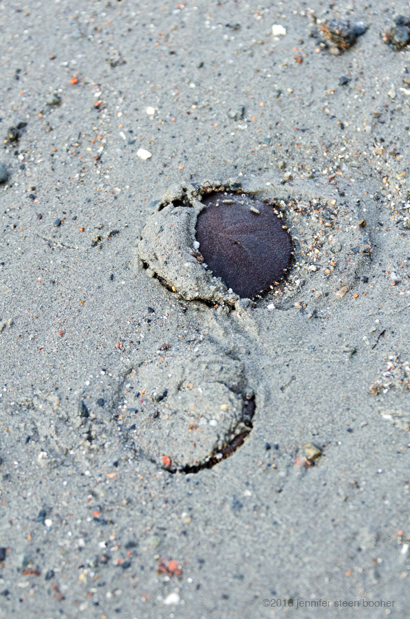
Live sand dollars burying themselves in the sand.
J: There was a hotel over here.
H: That was over there.
J: No, there was one at this end, too.
H: So maybe that was it, there was a hotel and he bought the land after. So now there’s this thing where they try to get all the people in Seal Harbor to donate a little money for their cause and they have this one guy, Larry, who maintains the area, and they pay him. They cover his health insurance and they pay him year-round. So he’s the guy that hauls the seaweed off the beach in the mornings with his tractor.
B: He mows the lawn and trims the trees.
H: So in the end it winds up that there are really wealthy people, you know, and they just want to see that in perpetuity for their grandkids. So they pay really well. We might give ten bucks or somethings, but the really wealthy people fund this guy’s existence.
B: Because the town won’t maintain it
H: Not to the level they want
B: So the town would mow the lawn, basically, of the green, because it’s a town green, but the Village Improvement Society wants to make it look nicer.
H: So I guess the town actually pays a little bit too, towards the guy. …

J: Bar Harbor has to do that [kind of maintenance] for the parks and everything. Maybe not quite as park-like…, but it’s a tourist thing.
H: But that’s more like the town wants it. Here it’s more about the wealthy people up on the hill want it for the beauty of the village.
B: So their grandkids can play ball on the green.
J: Well you have to admit, it is a really pretty green.
B: It is a pretty green, and a lot of people use it, which is nice. And a lot of people use the beach – oh they pay for the bathrooms, too.
J: Which are, I have to say, the prettiest public bathrooms ever. … How many bathrooms do you see with columns?

Photo courtesy of Seal Harbor Library.
OK, so speaking of the Seal Harbor Green, there are some stories there. First off, it’s another John D. Rockefeller, Jr. project [him again.] Second, they basically relocated the commercial district to make space for it. Most of the buildings on Main Street now were originally much closer to the harbor. For example:
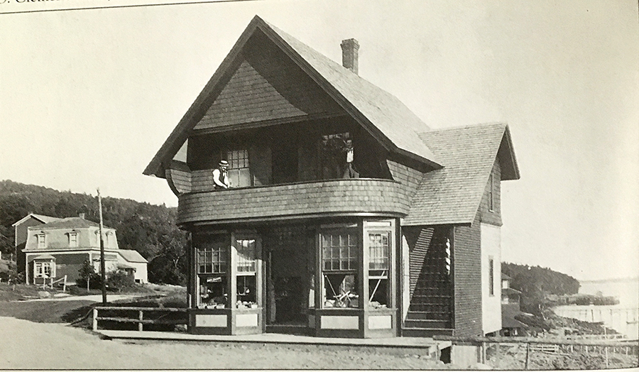
Photo from Vandenbergh and Shettleworth, Revisiting Seal Harbor, 1997.
In 1919, Rockefeller bought the old Glencove Hotel, tore it down, and gave the land to the town. I think you can see a corner of the Glencove sticking out from behind the market in the photo above.

Image courtesy of the Seal Harbor Library. This photo is also reproduced in
Revisiting Seal Harbor where the caption identifies the man on the left as John Tracy, a stonemason for B.W. Candage and Sons.
The stone coping is still there, although it is less dramatic since the ditch is gone and the street level is higher: only the top six inches or so still show. From The Cultural Landscape Foundation website: “Once the site was prepared, the Seal Harbor Village Improvement Society (VIS) created a park with an open lawn affording panoramic harbor views, deciduous shade trees, benches, and a granite-block retaining wall making the sloping site more usable for recreation.”

The green under construction, with the Seaside Hotel visible in the background. Image courtesy of the Seal Harbor Library.
“An adjacent town-owned beachfront parcel was improved as an extension of the green by famed doctor and summer resident Edward K. Dunham.” [Remember him?]

“Dunhams tree-planting on village green.” I believe that’s Dr. Dunham standing at center. Image courtesy of the Seal Harbor Library.
“He began work on the project with Beatrix Farrand, which was continued by his widow in 1922 after his sudden death. Farrand’s design includes a terrace with a curved stone wall flanked with rugosa roses and blackberries; the project was dedicated in Dunham’s memory.”

Construction of the Farrand-designed garden. Image courtesy of the Seal Harbor Library.

I want that bench. Image courtesy of the Seal Harbor Library.

Someone must have climbed into a tree to take this photo. Image courtesy of the Seal Harbor Library.

It is almost invisible now, hidden from the road and from the beach by thick hedges of rugosa roses. But the stonework is still stunning:

And back to the Coast Walk again, where we got distracted by all the gull footprints in the sand, and we noticed this:

the prints of a gull’s wing feathers where it beat the sand while taking off. You see similar prints in the snow where an owl or hawk has tried to snatch some little rodent.
We also noticed a lot of these, which I think are lugworm castings, or something similar. I’d love to learn more about them, but don’t know who to ask yet.

And the last bit of our conversation was drowned out by a helicopter. At first, we were worried because if you sight a helicopter around the island it’s usually the Lifeflight, and it means bad news for someone. We watched it land (in the field where the Seaside Inn once stood), realized it was a private flight, and guessed it might be people arriving for the Christmas holidays. Whew!
And that’s the end of Coast Walk 14, except for two last digressions: Cormorants and Salters.

These cormorants have been hanging out on an unused Yacht Club float in the middle of the harbor all summer.
And this is from an article by Catherine Schmitt in the 2007 Friends of Acadia Journal:
“Even brook trout, commonly considered a fish of remote, cool mountain rivers, wander into the sea on occasion. These sea-run brook trout, also known as salters, historically ranged as far south as Cape Cod, coastal Connecticut, and Long Island, although many populations have disappeared. … Three or four major areas in Acadia are known to host salters today, including Stanley Brook, where a team of scientists from federal and state agencies and the University of Maine are studying the movements of sea-run brook trout in an attempt to better manage the species and understand the overall health of small coastal ecosystems. … Brook trout in clear, cool, clean coastal streams such as Stanley Brook occasionally venture into salt water, especially when they are young. Last July, Letcher and his crew caught 40 sea-run trout off the beach at Seal Cove. In October they didn’t catch any. His theory is that the fish are heading upriver to spawn in the fall. But it’s also possible that the fish are residents of the stream and simply like to wander into the sea once in a while— likely for food, as sea-run trout grow much faster than their freshwater counterparts. In salt water, trout take on a rainbow of hues that distinguish them from fish that stay in fresh water; Stanley Brook salters are purple, green, brown, and silver when they return to upstream reaches. By fall, their colors have faded as they put all their energy into spawning. Letcher has tagged the fish with little wires that send out unique signals, which are detected by two receivers placed beneath the Route 3 bridge.”
Anyone know the results of that study?
_______________________________________________________
Addenda
6/30/16 You may know that Beatrix Farrand worked extensively with John D. Rockefeller, Jr. on the design and plantings of the carriage roads and bridges in the park. There’s a new book out that goes into meticulous detail about that work, including her collaboration with the Millers (of Miller Gardens.) Pages 64-65 discuss the plantings around the Stanley Brook bridge.
Brouse, Roxanne. The Public Spirited Beatrix Farrand of Mount Desert Island. Beatrix Farrand Society Press, 2016. [Printed by Oddi Printing, Iceland.]
8/1/17 There is a model of the J.T. Morse in the Great Harbor Maritime Museum, Northeast Harbor.


_______________________________________________________
Works Cited
Northeast and Seal Harbors, souvenir booklet, no author, publisher, or date, Mount Desert, ME. (Northeast Harbor Library special collections.)
Braun, Duane and Ruth, Guide to the Geology of Mount Desert Island and Acadia National Park, North Atlantic Books, Berkeley, CA, 2016.
May, Stephen, ” One Summer in Seal Harbor,” Johns Hopkins Magazine, June 1995.
Schmitt, Catherine, “The Salters of Stanley Brook,” Friends of Acadia Journal, Summer 2007.
Vandenbergh, Lydia and Shettleworth, Jr., Earle, Revisiting Seal Harbor and Acadia National Park, Arcadia Publishing, Charleston, SC, 1997.
Save
Save
Save

Pingback: Coast Walk 16: Bracy Cove – The Coast Walk Project
Pingback: Interview: Rodney Eason at Thuya Landing – The Coast Walk Project
Pingback: Exploring Seal Harbor Part 1: Downtown - Gift MDI